You are here: Home > Network List > TA - USArray Transportable Network (new EarthScope stations) Stations List
> Station T50A Nancy, KY, USA > Earthquake Result Viewer
T50A Nancy, KY, USA - Earthquake Result Viewer
| Earthquake location: |
Andreanof Islands, Aleutian Is. |
| Earthquake latitude/longitude: |
51.0/-179.9 |
| Earthquake time(UTC): |
2013/07/07 (188) 20:17:59 GMT |
| Earthquake Depth: |
6.8 km |
| Earthquake Magnitude: |
5.6 MB, 5.5 ML |
| Earthquake Catalog/Contributor: |
NEIC PDE/NEIC PDE-W |
|
| Network: |
TA USArray Transportable Network (new EarthScope stations) |
| Station: |
T50A Nancy, KY, USA |
| Lat/Lon: |
37.02 N/84.84 W |
| Elevation: |
302 m |
|
| Distance: |
65.2 deg |
| Az: |
61.469 deg |
| Baz: |
316.119 deg |
| Ray Param: |
0.058466468 |
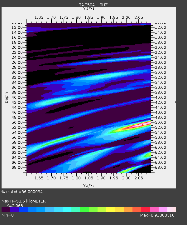
| Estimated Moho Depth: |
50.5 km |
| Estimated Crust Vp/Vs: |
2.07 |
| Assumed Crust Vp: |
6.476 km/s |
| Estimated Crust Vs: |
3.136 km/s |
| Estimated Crust Poisson's Ratio: |
0.35 |
|
| Radial Match: |
86.000084 % |
| Radial Bump: |
400 |
| Transverse Match: |
61.64847 % |
| Transverse Bump: |
322 |
| SOD ConfigId: |
512894 |
| Insert Time: |
2013-09-15 15:46:58.199 +0000 |
| GWidth: |
2.5 |
| Max Bumps: |
400 |
| Tol: |
0.001 |
|

Signal To Noise
| Channel | StoN | STA | LTA |
| TA:T50A: :BHZ:20130707T20:28:09.724978Z | 1.2720492 | 4.7460762E-7 | 3.7310477E-7 |
| TA:T50A: :BHN:20130707T20:28:09.724978Z | 1.0657511 | 2.6388875E-7 | 2.4760826E-7 |
| TA:T50A: :BHE:20130707T20:28:09.724978Z | 1.6932131 | 7.223363E-7 | 4.2660687E-7 |
| Arrivals |
| Ps | 8.6 SECOND |
| PpPs | 23 SECOND |
| PsPs/PpSs | 32 SECOND |


