You are here: Home > Network List > US - United States National Seismic Network Stations List
> Station MSO Missoula, Montana, USA > Earthquake Result Viewer
MSO Missoula, Montana, USA - Earthquake Result Viewer
*The percent match for this event was below the threshold and hence no stack was calculated.
| Earthquake location: |
Andreanof Islands, Aleutian Is. |
| Earthquake latitude/longitude: |
51.0/-179.9 |
| Earthquake time(UTC): |
2013/07/07 (188) 20:17:59 GMT |
| Earthquake Depth: |
6.8 km |
| Earthquake Magnitude: |
5.6 MB, 5.5 ML |
| Earthquake Catalog/Contributor: |
NEIC PDE/NEIC PDE-W |
|
| Network: |
US United States National Seismic Network |
| Station: |
MSO Missoula, Montana, USA |
| Lat/Lon: |
46.83 N/113.94 W |
| Elevation: |
1264 m |
|
| Distance: |
42.2 deg |
| Az: |
68.877 deg |
| Baz: |
300.92 deg |
| Ray Param: |
$rayparam |
*The percent match for this event was below the threshold and hence was not used in the summary stack. |
|
| Radial Match: |
60.94179 % |
| Radial Bump: |
400 |
| Transverse Match: |
40.62534 % |
| Transverse Bump: |
400 |
| SOD ConfigId: |
512894 |
| Insert Time: |
2013-09-15 15:52:16.037 +0000 |
| GWidth: |
2.5 |
| Max Bumps: |
400 |
| Tol: |
0.001 |
|
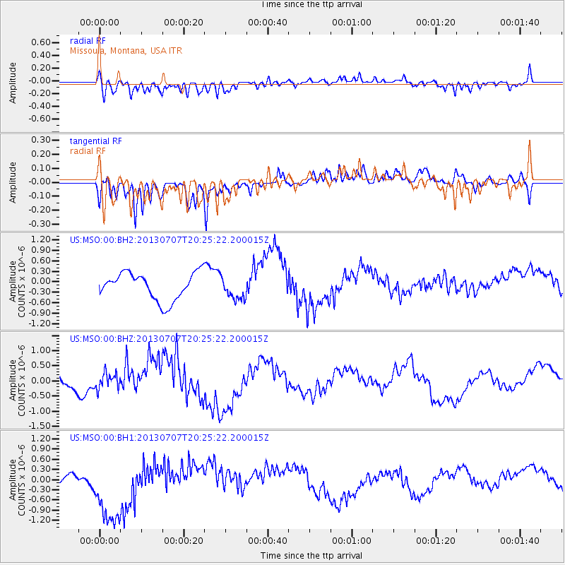
Signal To Noise
| Channel | StoN | STA | LTA |
| US:MSO:00:BHZ:20130707T20:25:22.200015Z | 0.42487514 | 2.7645635E-7 | 6.5067667E-7 |
| US:MSO:00:BH1:20130707T20:25:22.200015Z | 5.2233524 | 1.2347248E-6 | 2.3638549E-7 |
| US:MSO:00:BH2:20130707T20:25:22.200015Z | 0.8190715 | 3.214828E-7 | 3.9249662E-7 |
| Arrivals |
| Ps | |
| PpPs | |
| PsPs/PpSs | |


