You are here: Home > Network List > AU - Australian Seismological Centre Stations List
> Station XMIS Christmas Island Grants Well > Earthquake Result Viewer
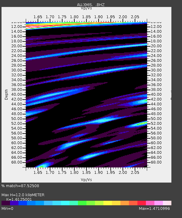
XMIS Christmas Island Grants Well - Earthquake Result Viewer
| Earthquake location: |
New Britain Region, P.N.G. |
| Earthquake latitude/longitude: |
-6.0/149.7 |
| Earthquake time(UTC): |
2013/07/07 (188) 20:30:06 GMT |
| Earthquake Depth: |
56 km |
| Earthquake Magnitude: |
6.6 MW, 6.1 MB, 6.6 MW |
| Earthquake Catalog/Contributor: |
NEIC PDE/NEIC PDE-W |
|
| Network: |
AU Australian Seismological Centre |
| Station: |
XMIS Christmas Island Grants Well |
| Lat/Lon: |
10.48 S/105.65 E |
| Elevation: |
210 m |
|
| Distance: |
43.8 deg |
| Az: |
261.19 deg |
| Baz: |
87.801 deg |
| Ray Param: |
0.07215927 |
| Estimated Moho Depth: |
12.0 km |
| Estimated Crust Vp/Vs: |
1.61 |
| Assumed Crust Vp: |
4.157 km/s |
| Estimated Crust Vs: |
2.578 km/s |
| Estimated Crust Poisson's Ratio: |
0.19 |
|
| Radial Match: |
87.52508 % |
| Radial Bump: |
400 |
| Transverse Match: |
65.9761 % |
| Transverse Bump: |
400 |
| SOD ConfigId: |
512894 |
| Insert Time: |
2013-09-15 16:01:02.748 +0000 |
| GWidth: |
2.5 |
| Max Bumps: |
400 |
| Tol: |
0.001 |
|

Signal To Noise
| Channel | StoN | STA | LTA |
| AU:XMIS: :BHZ:20130707T20:37:36.619012Z | 6.4781575 | 8.587724E-6 | 1.3256429E-6 |
| AU:XMIS: :BHN:20130707T20:37:36.619012Z | 1.2714592 | 1.5515606E-6 | 1.2202992E-6 |
| AU:XMIS: :BHE:20130707T20:37:36.619012Z | 3.5590732 | 4.756267E-6 | 1.336378E-6 |
| Arrivals |
| Ps | 1.8 SECOND |
| PpPs | 7.3 SECOND |
| PsPs/PpSs | 9.1 SECOND |


