You are here: Home > Network List > TA - USArray Transportable Network (new EarthScope stations) Stations List
> Station O48A Farmland, IN, USA > Earthquake Result Viewer
O48A Farmland, IN, USA - Earthquake Result Viewer
| Earthquake location: |
Near Coast Of Central Chile |
| Earthquake latitude/longitude: |
-32.7/-71.4 |
| Earthquake time(UTC): |
2014/08/23 (235) 22:32:23 GMT |
| Earthquake Depth: |
32 km |
| Earthquake Magnitude: |
6.4 MWW, 6.6 MWP |
| Earthquake Catalog/Contributor: |
NEIC PDE/NEIC COMCAT |
|
| Network: |
TA USArray Transportable Network (new EarthScope stations) |
| Station: |
O48A Farmland, IN, USA |
| Lat/Lon: |
40.26 N/85.16 W |
| Elevation: |
300 m |
|
| Distance: |
73.7 deg |
| Az: |
349.061 deg |
| Baz: |
167.933 deg |
| Ray Param: |
0.05278054 |
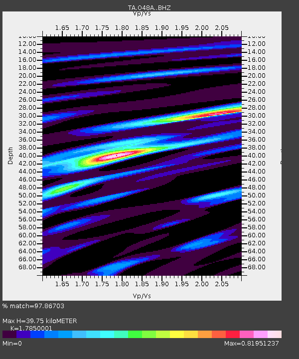
| Estimated Moho Depth: |
39.75 km |
| Estimated Crust Vp/Vs: |
1.79 |
| Assumed Crust Vp: |
6.498 km/s |
| Estimated Crust Vs: |
3.64 km/s |
| Estimated Crust Poisson's Ratio: |
0.27 |
|
| Radial Match: |
97.86703 % |
| Radial Bump: |
274 |
| Transverse Match: |
94.141 % |
| Transverse Bump: |
400 |
| SOD ConfigId: |
3390531 |
| Insert Time: |
2019-04-13 13:45:26.136 +0000 |
| GWidth: |
2.5 |
| Max Bumps: |
400 |
| Tol: |
0.001 |
|
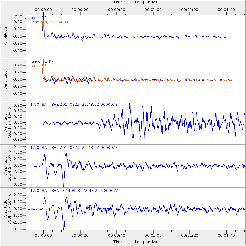
Signal To Noise
| Channel | StoN | STA | LTA |
| TA:O48A: :BHZ:20140823T22:43:22.900007Z | 22.49987 | 2.0418363E-6 | 9.07488E-8 |
| TA:O48A: :BHN:20140823T22:43:22.900007Z | 12.756333 | 8.964392E-7 | 7.027405E-8 |
| TA:O48A: :BHE:20140823T22:43:22.900007Z | 2.4821024 | 1.2422886E-7 | 5.0049852E-8 |
| Arrivals |
| Ps | 5.0 SECOND |
| PpPs | 16 SECOND |
| PsPs/PpSs | 21 SECOND |


