You are here: Home > Network List > CN - Canadian National Seismograph Network Stations List
> Station INK INUVIK, NT > Earthquake Result Viewer
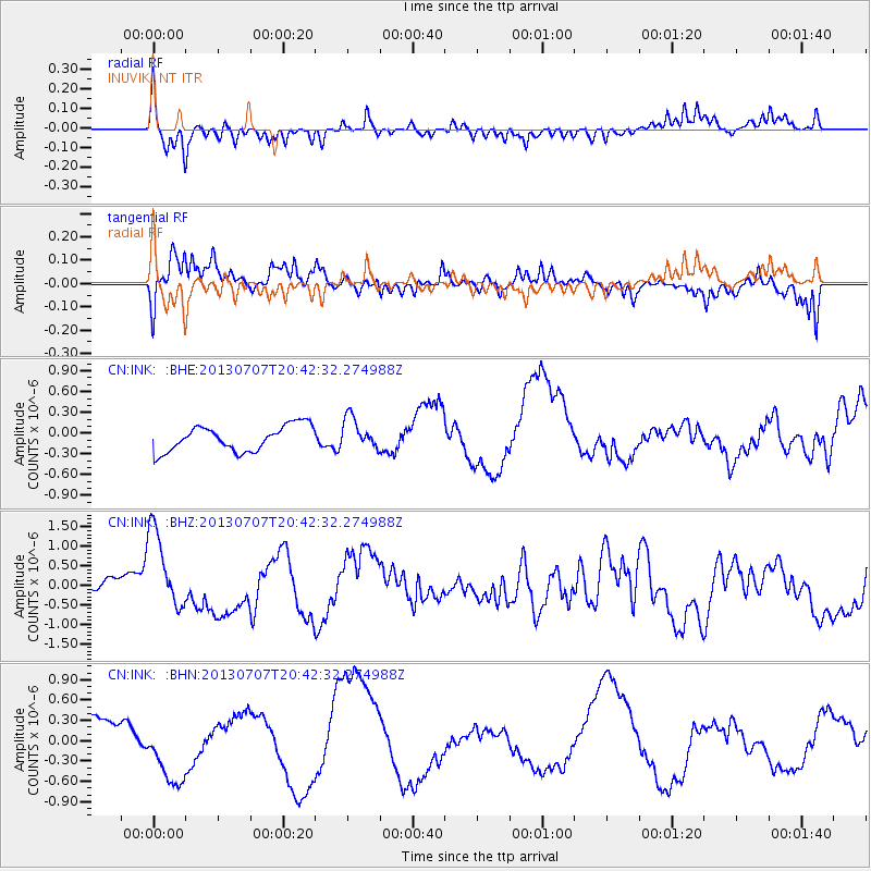
INK INUVIK, NT - Earthquake Result Viewer
*The percent match for this event was below the threshold and hence no stack was calculated.
| Earthquake location: |
New Britain Region, P.N.G. |
| Earthquake latitude/longitude: |
-6.0/149.7 |
| Earthquake time(UTC): |
2013/07/07 (188) 20:30:06 GMT |
| Earthquake Depth: |
56 km |
| Earthquake Magnitude: |
6.6 MW, 6.1 MB, 6.6 MW |
| Earthquake Catalog/Contributor: |
NEIC PDE/NEIC PDE-W |
|
| Network: |
CN Canadian National Seismograph Network |
| Station: |
INK INUVIK, NT |
| Lat/Lon: |
68.31 N/133.53 W |
| Elevation: |
44 m |
|
| Distance: |
90.7 deg |
| Az: |
21.22 deg |
| Baz: |
255.515 deg |
| Ray Param: |
$rayparam |
*The percent match for this event was below the threshold and hence was not used in the summary stack. |
|
| Radial Match: |
48.048046 % |
| Radial Bump: |
375 |
| Transverse Match: |
77.73938 % |
| Transverse Bump: |
400 |
| SOD ConfigId: |
512894 |
| Insert Time: |
2013-09-15 16:05:41.104 +0000 |
| GWidth: |
2.5 |
| Max Bumps: |
400 |
| Tol: |
0.001 |
|
Signal To Noise
| Channel | StoN | STA | LTA |
| CN:INK: :BHZ:20130707T20:42:32.274988Z | 4.761808 | 1.0705335E-6 | 2.248166E-7 |
| CN:INK: :BHN:20130707T20:42:32.274988Z | 1.6263368 | 4.7977335E-7 | 2.9500245E-7 |
| CN:INK: :BHE:20130707T20:42:32.274988Z | 1.232503 | 2.2674514E-7 | 1.8397125E-7 |
| Arrivals |
| Ps | |
| PpPs | |
| PsPs/PpSs | |


