You are here: Home > Network List > G - GEOSCOPE Stations List
> Station PPTF Pamatai - Papeete - Tahiti island - French Polynesia, France > Earthquake Result Viewer
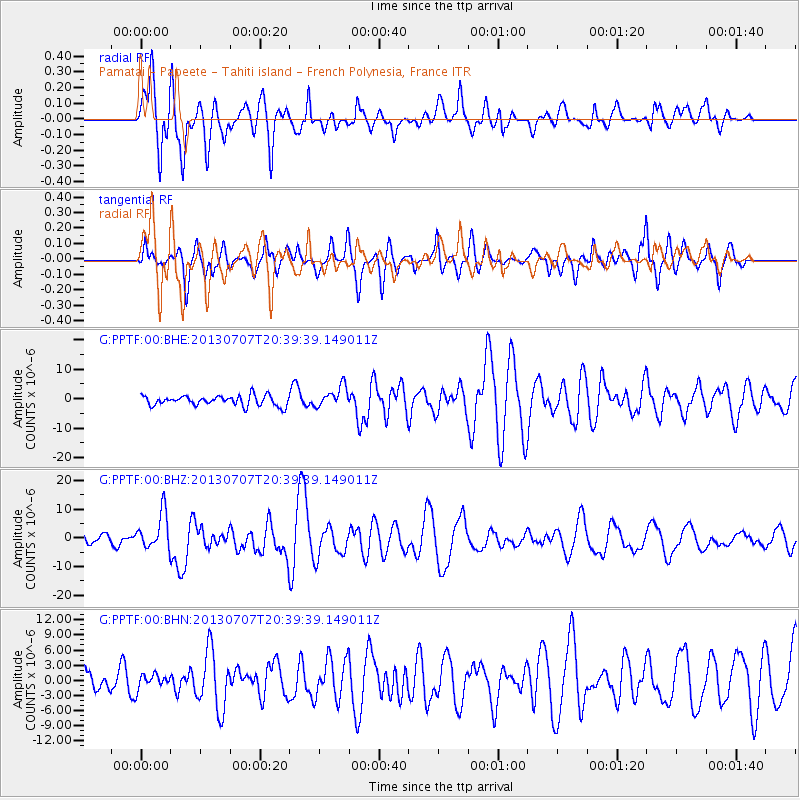
PPTF Pamatai - Papeete - Tahiti island - French Polynesia, France - Earthquake Result Viewer
*The percent match for this event was below the threshold and hence no stack was calculated.
| Earthquake location: |
New Britain Region, P.N.G. |
| Earthquake latitude/longitude: |
-6.0/149.7 |
| Earthquake time(UTC): |
2013/07/07 (188) 20:30:06 GMT |
| Earthquake Depth: |
56 km |
| Earthquake Magnitude: |
6.6 MW, 6.1 MB, 6.6 MW |
| Earthquake Catalog/Contributor: |
NEIC PDE/NEIC PDE-W |
|
| Network: |
G GEOSCOPE |
| Station: |
PPTF Pamatai - Papeete - Tahiti island - French Polynesia, France |
| Lat/Lon: |
17.59 S/149.57 W |
| Elevation: |
705 m |
|
| Distance: |
60.3 deg |
| Az: |
106.727 deg |
| Baz: |
273.071 deg |
| Ray Param: |
$rayparam |
*The percent match for this event was below the threshold and hence was not used in the summary stack. |
|
| Radial Match: |
76.22836 % |
| Radial Bump: |
400 |
| Transverse Match: |
63.729485 % |
| Transverse Bump: |
400 |
| SOD ConfigId: |
512894 |
| Insert Time: |
2013-09-15 16:06:21.435 +0000 |
| GWidth: |
2.5 |
| Max Bumps: |
400 |
| Tol: |
0.001 |
|
Signal To Noise
| Channel | StoN | STA | LTA |
| G:PPTF:00:BHZ:20130707T20:39:39.149011Z | 1.7278919 | 6.3477305E-6 | 3.673685E-6 |
| G:PPTF:00:BHN:20130707T20:39:39.149011Z | 0.43334195 | 1.4374993E-6 | 3.3172403E-6 |
| G:PPTF:00:BHE:20130707T20:39:39.149011Z | 2.0779245 | 3.549421E-6 | 1.7081569E-6 |
| Arrivals |
| Ps | |
| PpPs | |
| PsPs/PpSs | |


