You are here: Home > Network List > X812 - Deep Structure of Three Continental Sutures in Eastern North America Stations List
> Station QM20 Hay Lake, Maine, USA > Earthquake Result Viewer
QM20 Hay Lake, Maine, USA - Earthquake Result Viewer
| Earthquake location: |
Near Coast Of Central Chile |
| Earthquake latitude/longitude: |
-32.7/-71.4 |
| Earthquake time(UTC): |
2014/08/23 (235) 22:32:23 GMT |
| Earthquake Depth: |
32 km |
| Earthquake Magnitude: |
6.4 MWW, 6.6 MWP |
| Earthquake Catalog/Contributor: |
NEIC PDE/NEIC COMCAT |
|
| Network: |
X8 Deep Structure of Three Continental Sutures in Eastern North America |
| Station: |
QM20 Hay Lake, Maine, USA |
| Lat/Lon: |
46.13 N/68.72 W |
| Elevation: |
207 m |
|
| Distance: |
78.5 deg |
| Az: |
1.893 deg |
| Baz: |
182.295 deg |
| Ray Param: |
0.049555838 |
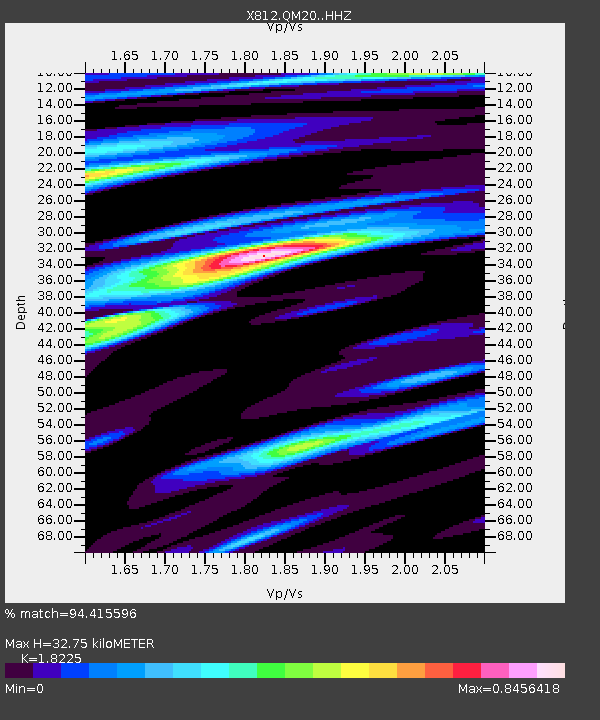
| Estimated Moho Depth: |
32.75 km |
| Estimated Crust Vp/Vs: |
1.82 |
| Assumed Crust Vp: |
6.419 km/s |
| Estimated Crust Vs: |
3.522 km/s |
| Estimated Crust Poisson's Ratio: |
0.28 |
|
| Radial Match: |
94.415596 % |
| Radial Bump: |
313 |
| Transverse Match: |
71.97099 % |
| Transverse Bump: |
400 |
| SOD ConfigId: |
3390531 |
| Insert Time: |
2019-04-13 13:46:33.760 +0000 |
| GWidth: |
2.5 |
| Max Bumps: |
400 |
| Tol: |
0.001 |
|

Signal To Noise
| Channel | StoN | STA | LTA |
| X8:QM20: :HHZ:20140823T22:43:50.160017Z | 22.62693 | 2.028619E-6 | 8.9655074E-8 |
| X8:QM20: :HHN:20140823T22:43:50.160017Z | 5.6111927 | 6.2562503E-7 | 1.1149591E-7 |
| X8:QM20: :HHE:20140823T22:43:50.160017Z | 1.5739834 | 2.0868615E-7 | 1.3258472E-7 |
| Arrivals |
| Ps | 4.3 SECOND |
| PpPs | 14 SECOND |
| PsPs/PpSs | 18 SECOND |


