You are here: Home > Network List > IU - Global Seismograph Network (GSN - IRIS/USGS) Stations List
> Station JOHN Johnston Island, USA > Earthquake Result Viewer
JOHN Johnston Island, USA - Earthquake Result Viewer

| Earthquake location: |
New Britain Region, P.N.G. |
| Earthquake latitude/longitude: |
-6.0/149.7 |
| Earthquake time(UTC): |
2013/07/07 (188) 20:30:06 GMT |
| Earthquake Depth: |
56 km |
| Earthquake Magnitude: |
6.6 MW, 6.1 MB, 6.6 MW |
| Earthquake Catalog/Contributor: |
NEIC PDE/NEIC PDE-W |
|
| Network: |
IU Global Seismograph Network (GSN - IRIS/USGS) |
| Station: |
JOHN Johnston Island, USA |
| Lat/Lon: |
16.73 N/169.53 W |
| Elevation: |
2.0 m |
|
| Distance: |
46.2 deg |
| Az: |
60.063 deg |
| Baz: |
244.087 deg |
| Ray Param: |
0.07062934 |
| Estimated Moho Depth: |
31.25 km |
| Estimated Crust Vp/Vs: |
1.99 |
| Assumed Crust Vp: |
4.24 km/s |
| Estimated Crust Vs: |
2.131 km/s |
| Estimated Crust Poisson's Ratio: |
0.33 |
|
| Radial Match: |
81.28389 % |
| Radial Bump: |
400 |
| Transverse Match: |
71.62934 % |
| Transverse Bump: |
400 |
| SOD ConfigId: |
512894 |
| Insert Time: |
2013-09-15 16:08:58.492 +0000 |
| GWidth: |
2.5 |
| Max Bumps: |
400 |
| Tol: |
0.001 |
|
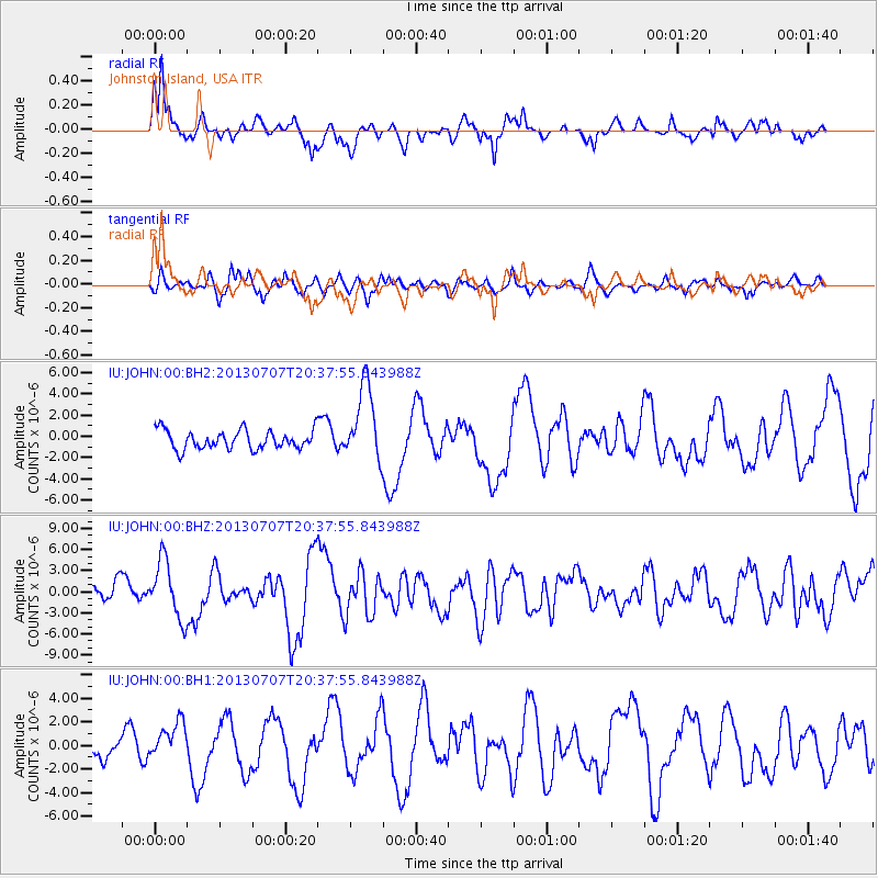
Signal To Noise
| Channel | StoN | STA | LTA |
| IU:JOHN:00:BHZ:20130707T20:37:55.843988Z | 3.5408473 | 4.107053E-6 | 1.1599068E-6 |
| IU:JOHN:00:BH1:20130707T20:37:55.843988Z | 1.7234439 | 1.5989739E-6 | 9.277784E-7 |
| IU:JOHN:00:BH2:20130707T20:37:55.843988Z | 4.0652757 | 3.573101E-6 | 8.78932E-7 |
| Arrivals |
| Ps | 7.5 SECOND |
| PpPs | 22 SECOND |
| PsPs/PpSs | 29 SECOND |


