You are here: Home > Network List > UW - Pacific Northwest Regional Seismic Network Stations List
> Station PASS Maple Falls, WA, USA > Earthquake Result Viewer
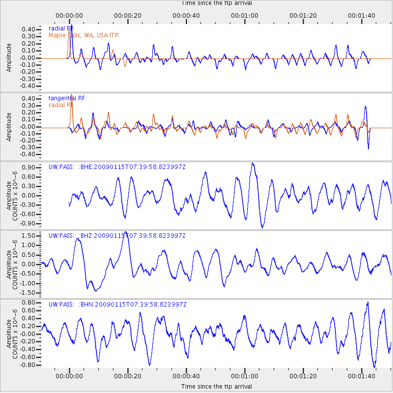
PASS Maple Falls, WA, USA - Earthquake Result Viewer

| Earthquake location: |
Southeast Of Loyalty Islands |
| Earthquake latitude/longitude: |
-22.4/170.6 |
| Earthquake time(UTC): |
2009/01/15 (015) 07:27:20 GMT |
| Earthquake Depth: |
27 km |
| Earthquake Magnitude: |
5.8 MB, 6.5 MS, 6.7 MW, 6.6 MW |
| Earthquake Catalog/Contributor: |
WHDF/NEIC |
|
| Network: |
UW Pacific Northwest Regional Seismic Network |
| Station: |
PASS Maple Falls, WA, USA |
| Lat/Lon: |
49.00 N/122.09 W |
| Elevation: |
174 m |
|
| Distance: |
92.8 deg |
| Az: |
37.461 deg |
| Baz: |
238.754 deg |
| Ray Param: |
0.041376702 |
| Estimated Moho Depth: |
69.75 km |
| Estimated Crust Vp/Vs: |
1.77 |
| Assumed Crust Vp: |
6.566 km/s |
| Estimated Crust Vs: |
3.699 km/s |
| Estimated Crust Poisson's Ratio: |
0.27 |
|
| Radial Match: |
80.39554 % |
| Radial Bump: |
400 |
| Transverse Match: |
55.074783 % |
| Transverse Bump: |
400 |
| SOD ConfigId: |
2834 |
| Insert Time: |
2010-02-27 04:57:31.448 +0000 |
| GWidth: |
2.5 |
| Max Bumps: |
400 |
| Tol: |
0.001 |
|
Signal To Noise
| Channel | StoN | STA | LTA |
| UW:PASS: :BHZ:20090115T07:39:58.823997Z | 5.6136394 | 8.631287E-7 | 1.5375565E-7 |
| UW:PASS: :BHN:20090115T07:39:58.823997Z | 1.6999205 | 2.307122E-7 | 1.357194E-7 |
| UW:PASS: :BHE:20090115T07:39:58.823997Z | 1.2704582 | 3.5580214E-7 | 2.8005812E-7 |
| Arrivals |
| Ps | 8.4 SECOND |
| PpPs | 29 SECOND |
| PsPs/PpSs | 37 SECOND |


