You are here: Home > Network List > JP - Japan Meteorological Agency Seismic Network Stations List
> Station JHJ2 Hachijojima Island > Earthquake Result Viewer
JHJ2 Hachijojima Island - Earthquake Result Viewer
| Earthquake location: |
New Britain Region, P.N.G. |
| Earthquake latitude/longitude: |
-6.0/149.7 |
| Earthquake time(UTC): |
2013/07/07 (188) 20:30:06 GMT |
| Earthquake Depth: |
56 km |
| Earthquake Magnitude: |
6.6 MW, 6.1 MB, 6.6 MW |
| Earthquake Catalog/Contributor: |
NEIC PDE/NEIC PDE-W |
|
| Network: |
JP Japan Meteorological Agency Seismic Network |
| Station: |
JHJ2 Hachijojima Island |
| Lat/Lon: |
33.12 N/139.81 E |
| Elevation: |
70 m |
|
| Distance: |
40.0 deg |
| Az: |
347.051 deg |
| Baz: |
164.6 deg |
| Ray Param: |
0.07447185 |
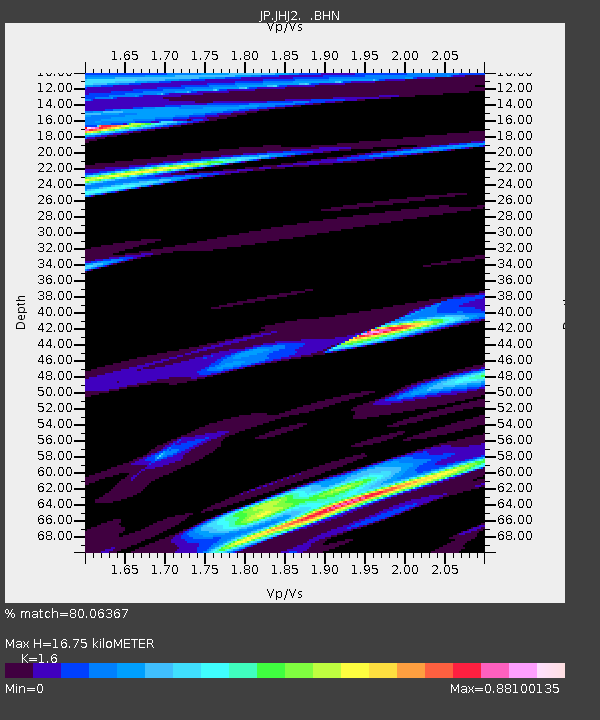
| Estimated Moho Depth: |
16.75 km |
| Estimated Crust Vp/Vs: |
1.60 |
| Assumed Crust Vp: |
4.662 km/s |
| Estimated Crust Vs: |
2.914 km/s |
| Estimated Crust Poisson's Ratio: |
0.18 |
|
| Radial Match: |
80.06367 % |
| Radial Bump: |
400 |
| Transverse Match: |
74.56463 % |
| Transverse Bump: |
400 |
| SOD ConfigId: |
512894 |
| Insert Time: |
2013-09-15 16:09:53.434 +0000 |
| GWidth: |
2.5 |
| Max Bumps: |
400 |
| Tol: |
0.001 |
|

Signal To Noise
| Channel | StoN | STA | LTA |
| JP:JHJ2: :BHZ:20130707T20:37:06.149988Z | 6.7195253 | 8.9808555E-6 | 1.3365312E-6 |
| JP:JHJ2: :BHN:20130707T20:37:06.149988Z | 5.1314597 | 5.1108245E-6 | 9.959787E-7 |
| JP:JHJ2: :BHE:20130707T20:37:06.149988Z | 1.1883149 | 1.953644E-6 | 1.6440457E-6 |
| Arrivals |
| Ps | 2.2 SECOND |
| PpPs | 9.0 SECOND |
| PsPs/PpSs | 11 SECOND |


