You are here: Home > Network List > X812 - Deep Structure of Three Continental Sutures in Eastern North America Stations List
> Station QMHP Harpswell, Maine > Earthquake Result Viewer
QMHP Harpswell, Maine - Earthquake Result Viewer
| Earthquake location: |
Near Coast Of Central Chile |
| Earthquake latitude/longitude: |
-32.7/-71.4 |
| Earthquake time(UTC): |
2014/08/23 (235) 22:32:23 GMT |
| Earthquake Depth: |
32 km |
| Earthquake Magnitude: |
6.4 MWW, 6.6 MWP |
| Earthquake Catalog/Contributor: |
NEIC PDE/NEIC COMCAT |
|
| Network: |
X8 Deep Structure of Three Continental Sutures in Eastern North America |
| Station: |
QMHP Harpswell, Maine |
| Lat/Lon: |
43.75 N/70.01 W |
| Elevation: |
22 m |
|
| Distance: |
76.1 deg |
| Az: |
1.027 deg |
| Baz: |
181.195 deg |
| Ray Param: |
0.05118291 |
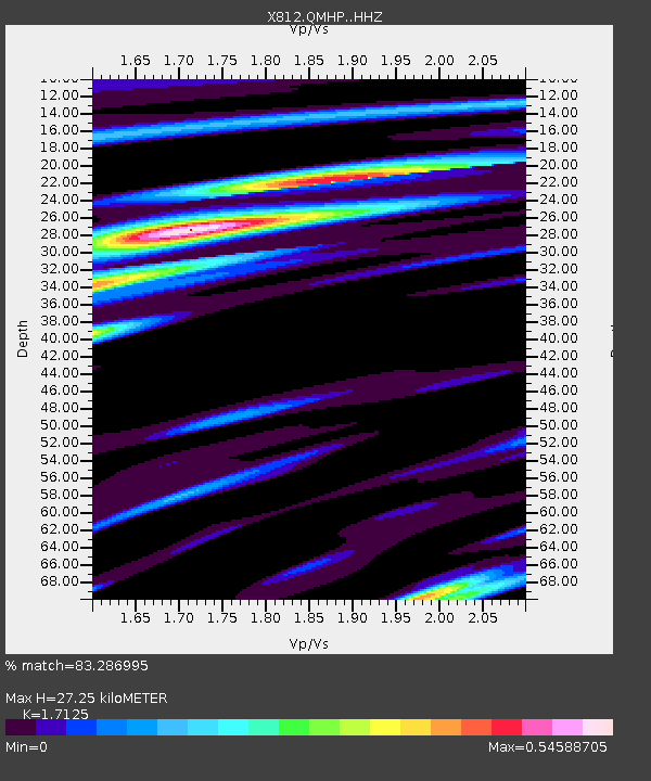
| Estimated Moho Depth: |
27.25 km |
| Estimated Crust Vp/Vs: |
1.71 |
| Assumed Crust Vp: |
6.419 km/s |
| Estimated Crust Vs: |
3.748 km/s |
| Estimated Crust Poisson's Ratio: |
0.24 |
|
| Radial Match: |
83.286995 % |
| Radial Bump: |
400 |
| Transverse Match: |
60.098873 % |
| Transverse Bump: |
400 |
| SOD ConfigId: |
3390531 |
| Insert Time: |
2019-04-13 13:46:51.195 +0000 |
| GWidth: |
2.5 |
| Max Bumps: |
400 |
| Tol: |
0.001 |
|

Signal To Noise
| Channel | StoN | STA | LTA |
| X8:QMHP: :HHZ:20140823T22:43:36.699995Z | 10.305161 | 1.9116203E-6 | 1.8550125E-7 |
| X8:QMHP: :HHN:20140823T22:43:36.699995Z | 4.2359004 | 6.997541E-7 | 1.6519606E-7 |
| X8:QMHP: :HHE:20140823T22:43:36.699995Z | 0.81069523 | 1.2821079E-7 | 1.5814918E-7 |
| Arrivals |
| Ps | 3.1 SECOND |
| PpPs | 11 SECOND |
| PsPs/PpSs | 14 SECOND |


