You are here: Home > Network List > TA - USArray Transportable Network (new EarthScope stations) Stations List
> Station R11A Troy Canyon, Currant, NV, USA > Earthquake Result Viewer
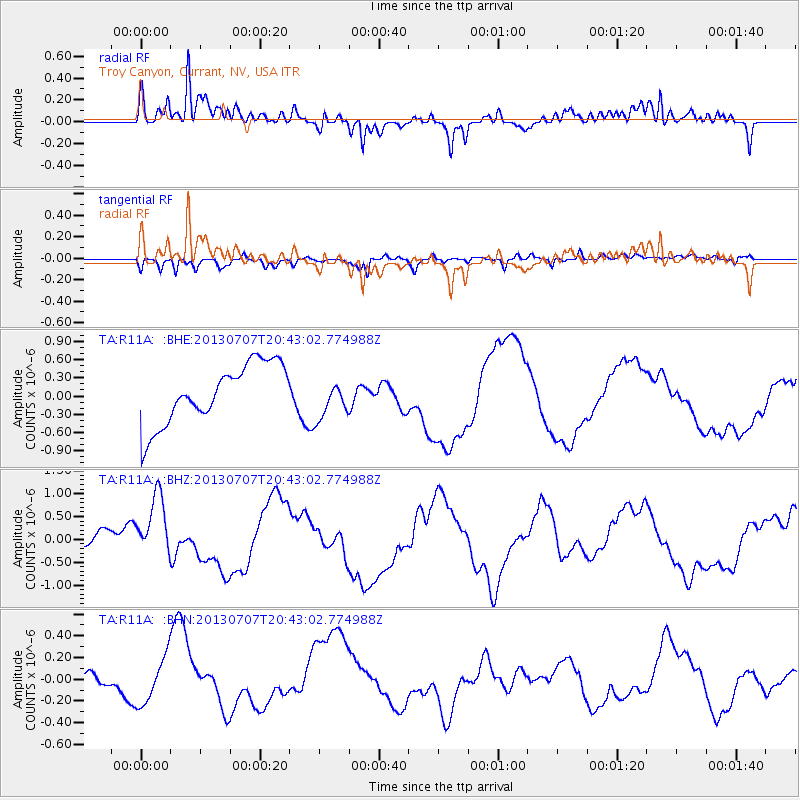
R11A Troy Canyon, Currant, NV, USA - Earthquake Result Viewer
*The percent match for this event was below the threshold and hence no stack was calculated.
| Earthquake location: |
New Britain Region, P.N.G. |
| Earthquake latitude/longitude: |
-6.0/149.7 |
| Earthquake time(UTC): |
2013/07/07 (188) 20:30:06 GMT |
| Earthquake Depth: |
56 km |
| Earthquake Magnitude: |
6.6 MW, 6.1 MB, 6.6 MW |
| Earthquake Catalog/Contributor: |
NEIC PDE/NEIC PDE-W |
|
| Network: |
TA USArray Transportable Network (new EarthScope stations) |
| Station: |
R11A Troy Canyon, Currant, NV, USA |
| Lat/Lon: |
38.35 N/115.59 W |
| Elevation: |
1756 m |
|
| Distance: |
97.4 deg |
| Az: |
52.203 deg |
| Baz: |
268.174 deg |
| Ray Param: |
$rayparam |
*The percent match for this event was below the threshold and hence was not used in the summary stack. |
|
| Radial Match: |
67.51527 % |
| Radial Bump: |
400 |
| Transverse Match: |
54.59513 % |
| Transverse Bump: |
400 |
| SOD ConfigId: |
512894 |
| Insert Time: |
2013-09-15 16:13:50.080 +0000 |
| GWidth: |
2.5 |
| Max Bumps: |
400 |
| Tol: |
0.001 |
|
Signal To Noise
| Channel | StoN | STA | LTA |
| TA:R11A: :BHZ:20130707T20:43:02.774988Z | 3.1644878 | 7.1897983E-7 | 2.2720259E-7 |
| TA:R11A: :BHN:20130707T20:43:02.774988Z | 1.0932013 | 2.1736885E-7 | 1.9883699E-7 |
| TA:R11A: :BHE:20130707T20:43:02.774988Z | 0.64694726 | 3.1635844E-7 | 4.8900193E-7 |
| Arrivals |
| Ps | |
| PpPs | |
| PsPs/PpSs | |


