You are here: Home > Network List > XD14 - Illuminating the architecture of the greater Mount St. Helens magmatic systems f Stations List
> Station MJ07 "Mount St Helens, WA" > Earthquake Result Viewer
MJ07 "Mount St Helens, WA" - Earthquake Result Viewer
| Earthquake location: |
Near Coast Of Central Chile |
| Earthquake latitude/longitude: |
-32.7/-71.4 |
| Earthquake time(UTC): |
2014/08/23 (235) 22:32:23 GMT |
| Earthquake Depth: |
32 km |
| Earthquake Magnitude: |
6.4 MWW, 6.6 MWP |
| Earthquake Catalog/Contributor: |
NEIC PDE/NEIC COMCAT |
|
| Network: |
XD Illuminating the architecture of the greater Mount St. Helens magmatic systems f |
| Station: |
MJ07 "Mount St Helens, WA" |
| Lat/Lon: |
46.18 N/122.06 W |
| Elevation: |
509 m |
|
| Distance: |
90.9 deg |
| Az: |
327.486 deg |
| Baz: |
139.289 deg |
| Ray Param: |
0.04163792 |
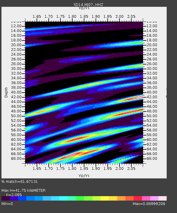
| Estimated Moho Depth: |
41.75 km |
| Estimated Crust Vp/Vs: |
2.10 |
| Assumed Crust Vp: |
6.566 km/s |
| Estimated Crust Vs: |
3.134 km/s |
| Estimated Crust Poisson's Ratio: |
0.35 |
|
| Radial Match: |
81.67131 % |
| Radial Bump: |
400 |
| Transverse Match: |
73.55284 % |
| Transverse Bump: |
400 |
| SOD ConfigId: |
3390531 |
| Insert Time: |
2019-04-13 13:47:24.160 +0000 |
| GWidth: |
2.5 |
| Max Bumps: |
400 |
| Tol: |
0.001 |
|

Signal To Noise
| Channel | StoN | STA | LTA |
| XD:MJ07: :HHZ:20140823T22:44:52.239973Z | 9.611296 | 5.948815E-7 | 6.189399E-8 |
| XD:MJ07: :HHN:20140823T22:44:52.239973Z | 2.0582852 | 2.1399303E-7 | 1.03966656E-7 |
| XD:MJ07: :HHE:20140823T22:44:52.239973Z | 2.4446747 | 1.7750828E-7 | 7.261018E-8 |
| Arrivals |
| Ps | 7.1 SECOND |
| PpPs | 19 SECOND |
| PsPs/PpSs | 26 SECOND |


