You are here: Home > Network List > UW - Pacific Northwest Regional Seismic Network Stations List
> Station PASS Maple Falls, WA, USA > Earthquake Result Viewer
PASS Maple Falls, WA, USA - Earthquake Result Viewer
| Earthquake location: |
Kyushu, Japan |
| Earthquake latitude/longitude: |
31.1/130.0 |
| Earthquake time(UTC): |
2009/09/03 (246) 13:26:18 GMT |
| Earthquake Depth: |
166 km |
| Earthquake Magnitude: |
5.9 MB, 6.2 MW, 6.2 MW |
| Earthquake Catalog/Contributor: |
WHDF/NEIC |
|
| Network: |
UW Pacific Northwest Regional Seismic Network |
| Station: |
PASS Maple Falls, WA, USA |
| Lat/Lon: |
49.00 N/122.09 W |
| Elevation: |
174 m |
|
| Distance: |
77.7 deg |
| Az: |
39.909 deg |
| Baz: |
303.356 deg |
| Ray Param: |
0.049760826 |
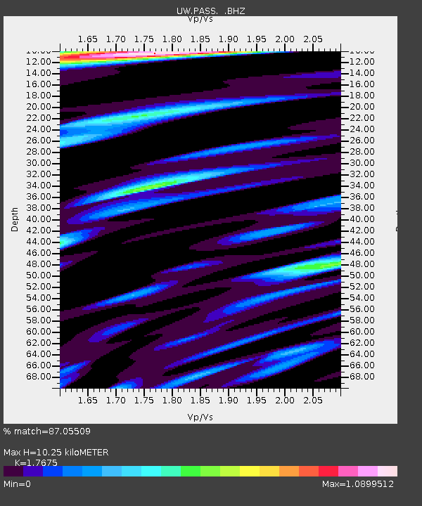
| Estimated Moho Depth: |
10.25 km |
| Estimated Crust Vp/Vs: |
1.77 |
| Assumed Crust Vp: |
6.566 km/s |
| Estimated Crust Vs: |
3.715 km/s |
| Estimated Crust Poisson's Ratio: |
0.26 |
|
| Radial Match: |
87.05509 % |
| Radial Bump: |
400 |
| Transverse Match: |
81.55853 % |
| Transverse Bump: |
400 |
| SOD ConfigId: |
2622 |
| Insert Time: |
2010-02-27 04:57:56.976 +0000 |
| GWidth: |
2.5 |
| Max Bumps: |
400 |
| Tol: |
0.001 |
|
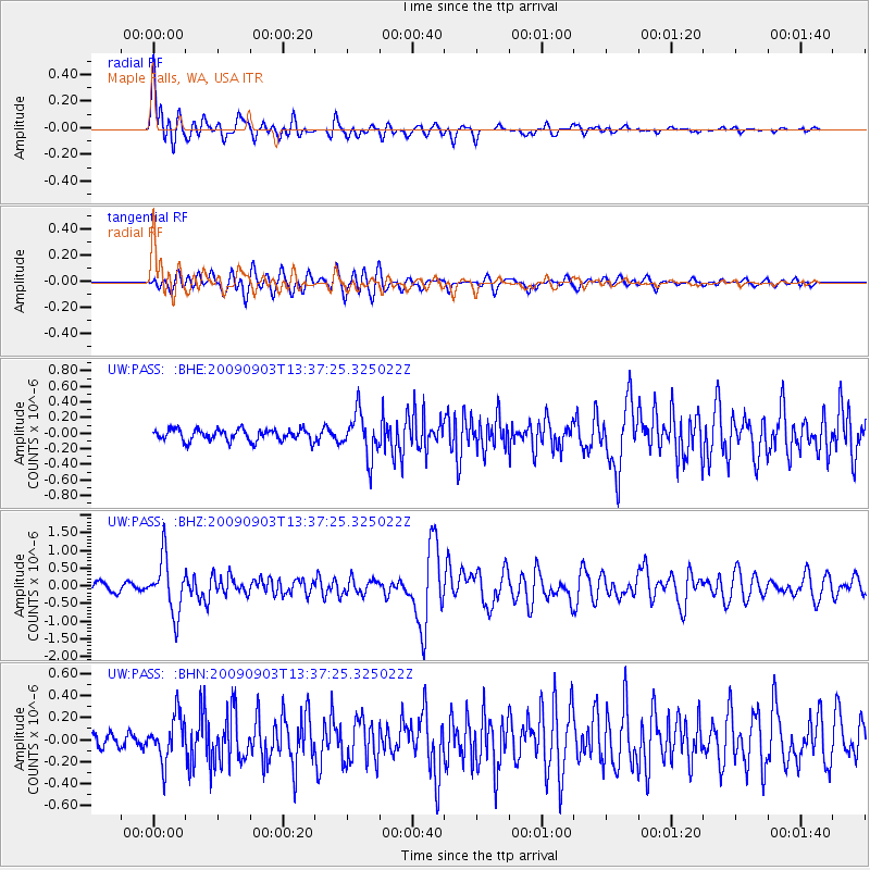
Signal To Noise
| Channel | StoN | STA | LTA |
| UW:PASS: :BHZ:20090903T13:37:25.325022Z | 7.6369348 | 7.730783E-7 | 1.0122887E-7 |
| UW:PASS: :BHN:20090903T13:37:25.325022Z | 2.5857291 | 2.0332817E-7 | 7.863475E-8 |
| UW:PASS: :BHE:20090903T13:37:25.325022Z | 3.8157375 | 2.828599E-7 | 7.4129815E-8 |
| Arrivals |
| Ps | 1.2 SECOND |
| PpPs | 4.2 SECOND |
| PsPs/PpSs | 5.4 SECOND |


