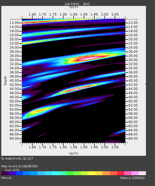
PASS Maple Falls, WA, USA - Earthquake Result Viewer

Earthquake location: Off Coast Of Jalisco, Mexico
Earthquake latitude/longitude: 18.8/-107.3
Earthquake time(UTC): 2009/09/24 (267) 07:16:19 GMT
Earthquake Depth: 10 km
Earthquake Magnitude: 5.8 MB, 6.2 MS, 6.3 MW, 6.3 MW
Earthquake Catalog/Contributor: WHDF/NEIC
Network: UW Pacific Northwest Regional Seismic Network
Station: PASS Maple Falls, WA, USA
Lat/Lon: 49.00 N/122.09 W
Elevation: 174 m
Distance: 32.4 deg
Az: 341.761 deg
Baz: 153.248 deg
Ray Param: 0.07868011
Estimated Moho Depth: 43.5 km
Estimated Crust Vp/Vs: 1.88
Assumed Crust Vp: 6.566 km/s
Estimated Crust Vs: 3.502 km/s
Estimated Crust Poisson's Ratio: 0.30
Radial Match: 81.61327 %
Radial Bump: 400
Transverse Match: 75.83345 %
Transverse Bump: 400
SOD ConfigId: 2622
Insert Time: 2010-02-27 04:57:58.798 +0000
GWidth: 2.5
Max Bumps: 400
Tol: 0.001

Signal To Noise

ChannelStoNSTALTA
UW:PASS: :BHZ:20090924T07:22:18.625Z15.4313871.30175E-68.4357296E-8
UW:PASS: :BHN:20090924T07:22:18.625Z3.28829317.29343E-72.2179988E-7
UW:PASS: :BHE:20090924T07:22:18.625Z3.14429973.3469965E-71.06446485E-7
Arrivals
Ps6.3 SECOND
PpPs18 SECOND
PsPs/PpSs24 SECOND