You are here: Home > Network List > JP - Japan Meteorological Agency Seismic Network Stations List
> Station JOW Okinawa Kunigami > Earthquake Result Viewer
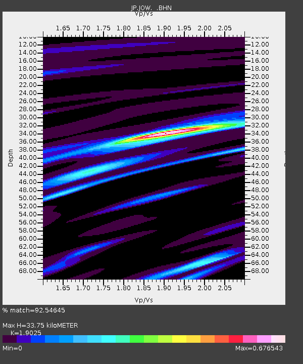
JOW Okinawa Kunigami - Earthquake Result Viewer
| Earthquake location: |
Java, Indonesia |
| Earthquake latitude/longitude: |
-8.8/113.0 |
| Earthquake time(UTC): |
2013/07/08 (189) 02:13:40 GMT |
| Earthquake Depth: |
60 km |
| Earthquake Magnitude: |
5.7 MW, 5.5 MB, 5.8 MW |
| Earthquake Catalog/Contributor: |
NEIC PDE/NEIC PDE-W |
|
| Network: |
JP Japan Meteorological Agency Seismic Network |
| Station: |
JOW Okinawa Kunigami |
| Lat/Lon: |
26.84 N/128.27 E |
| Elevation: |
220 m |
|
| Distance: |
38.4 deg |
| Az: |
22.263 deg |
| Baz: |
204.776 deg |
| Ray Param: |
0.075412534 |
| Estimated Moho Depth: |
33.75 km |
| Estimated Crust Vp/Vs: |
1.90 |
| Assumed Crust Vp: |
6.183 km/s |
| Estimated Crust Vs: |
3.25 km/s |
| Estimated Crust Poisson's Ratio: |
0.31 |
|
| Radial Match: |
92.54645 % |
| Radial Bump: |
138 |
| Transverse Match: |
63.21202 % |
| Transverse Bump: |
400 |
| SOD ConfigId: |
512894 |
| Insert Time: |
2013-09-15 16:22:01.402 +0000 |
| GWidth: |
2.5 |
| Max Bumps: |
400 |
| Tol: |
0.001 |
|

Signal To Noise
| Channel | StoN | STA | LTA |
| JP:JOW: :BHZ:20130708T02:20:25.800012Z | 1.5927953 | 3.5508717E-7 | 2.2293334E-7 |
| JP:JOW: :BHN:20130708T02:20:25.800012Z | 1.7235496 | 3.632093E-7 | 2.107333E-7 |
| JP:JOW: :BHE:20130708T02:20:25.800012Z | 1.0380955 | 2.3848025E-7 | 2.2972863E-7 |
| Arrivals |
| Ps | 5.2 SECOND |
| PpPs | 15 SECOND |
| PsPs/PpSs | 20 SECOND |


