You are here: Home > Network List > UW - Pacific Northwest Regional Seismic Network Stations List
> Station PASS Maple Falls, WA, USA > Earthquake Result Viewer
PASS Maple Falls, WA, USA - Earthquake Result Viewer
| Earthquake location: |
Tonga Islands Region |
| Earthquake latitude/longitude: |
-23.0/-174.7 |
| Earthquake time(UTC): |
2009/03/19 (078) 18:17:40 GMT |
| Earthquake Depth: |
34 km |
| Earthquake Magnitude: |
7.0 MB, 7.6 MS, 7.6 MW, 7.6 MW |
| Earthquake Catalog/Contributor: |
WHDF/NEIC |
|
| Network: |
UW Pacific Northwest Regional Seismic Network |
| Station: |
PASS Maple Falls, WA, USA |
| Lat/Lon: |
49.00 N/122.09 W |
| Elevation: |
174 m |
|
| Distance: |
85.7 deg |
| Az: |
31.636 deg |
| Baz: |
227.19 deg |
| Ray Param: |
0.04456429 |
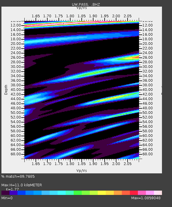
| Estimated Moho Depth: |
11.0 km |
| Estimated Crust Vp/Vs: |
1.77 |
| Assumed Crust Vp: |
6.566 km/s |
| Estimated Crust Vs: |
3.71 km/s |
| Estimated Crust Poisson's Ratio: |
0.27 |
|
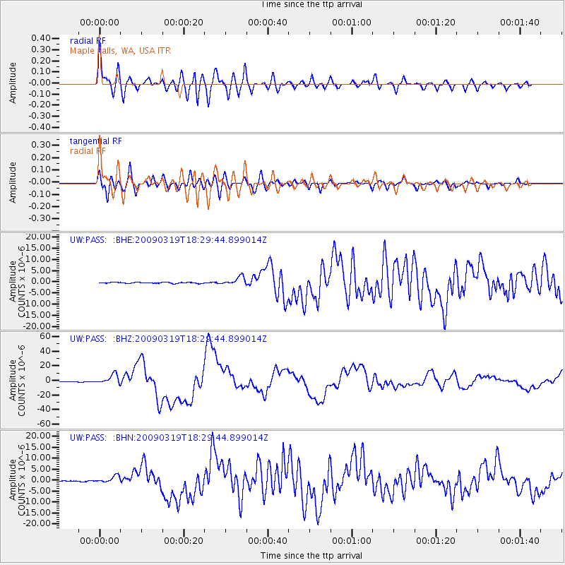
| Radial Match: |
89.7685 % |
| Radial Bump: |
400 |
| Transverse Match: |
80.48296 % |
| Transverse Bump: |
400 |
| SOD ConfigId: |
2658 |
| Insert Time: |
2010-02-27 04:58:14.958 +0000 |
| GWidth: |
2.5 |
| Max Bumps: |
400 |
| Tol: |
0.001 |
|
Signal To Noise
| Channel | StoN | STA | LTA |
| UW:PASS: :BHZ:20090319T18:29:44.899014Z | 19.469746 | 6.7994965E-6 | 3.4923397E-7 |
| UW:PASS: :BHN:20090319T18:29:44.899014Z | 7.1128297 | 1.5920732E-6 | 2.238312E-7 |
| UW:PASS: :BHE:20090319T18:29:44.899014Z | 8.298341 | 1.8952815E-6 | 2.2839282E-7 |
| Arrivals |
| Ps | 1.3 SECOND |
| PpPs | 4.5 SECOND |
| PsPs/PpSs | 5.8 SECOND |


