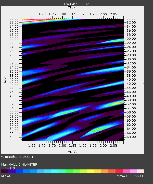
PASS Maple Falls, WA, USA - Earthquake Result Viewer
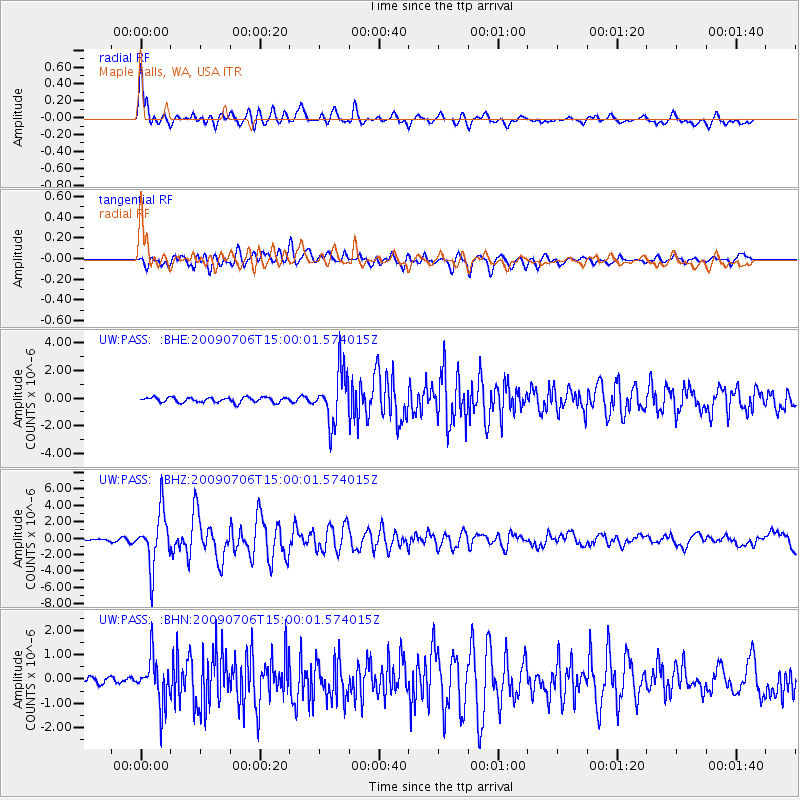
Earthquake location: Rat Islands, Aleutian Islands
Earthquake latitude/longitude: 50.4/177.0
Earthquake time(UTC): 2009/07/06 (187) 14:53:12 GMT
Earthquake Depth: 22 km
Earthquake Magnitude: 6.0 MB, 5.8 MS, 6.1 MW, 6.0 MW
Earthquake Catalog/Contributor: WHDF/NEIC
Network: UW Pacific Northwest Regional Seismic Network
Station: PASS Maple Falls, WA, USA
Lat/Lon: 49.00 N/122.09 W
Elevation: 174 m
Distance: 38.4 deg
Az: 67.777 deg
Baz: 295.989 deg
Ray Param: 0.07552628
Estimated Moho Depth: 11.0 km
Estimated Crust Vp/Vs: 1.60
Assumed Crust Vp: 6.566 km/s
Estimated Crust Vs: 4.104 km/s
Estimated Crust Poisson's Ratio: 0.18
Radial Match: 84.04473 %
Radial Bump: 400
Transverse Match: 85.0753 %
Transverse Bump: 400
SOD ConfigId: 2648
Insert Time: 2010-02-27 04:58:16.852 +0000
GWidth: 2.5
Max Bumps: 400
Tol: 0.001

Signal To Noise

ChannelStoNSTALTA
UW:PASS: :BHZ:20090706T15:00:01.574015Z31.6193073.31556E-61.04858714E-7
UW:PASS: :BHN:20090706T15:00:01.574015Z6.04026279.403806E-71.5568537E-7
UW:PASS: :BHE:20090706T15:00:01.574015Z10.2282151.8723186E-61.8305428E-7
Arrivals
Ps1.1 SECOND
PpPs4.0 SECOND
PsPs/PpSs5.1 SECOND