You are here: Home > Network List > UW - Pacific Northwest Regional Seismic Network Stations List
> Station PASS Maple Falls, WA, USA > Earthquake Result Viewer
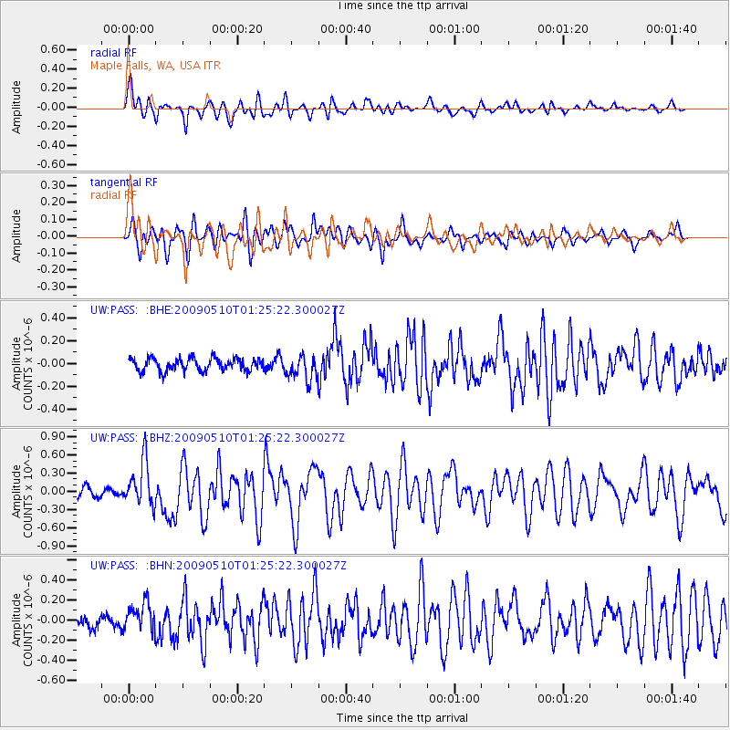
PASS Maple Falls, WA, USA - Earthquake Result Viewer
*The percent match for this event was below the threshold and hence no stack was calculated.
| Earthquake location: |
Off Coast Of Ecuador |
| Earthquake latitude/longitude: |
1.4/-85.2 |
| Earthquake time(UTC): |
2009/05/10 (130) 01:16:06 GMT |
| Earthquake Depth: |
6.0 km |
| Earthquake Magnitude: |
5.5 MB, 5.7 MS, 6.1 MW, 6.1 MW |
| Earthquake Catalog/Contributor: |
WHDF/NEIC |
|
| Network: |
UW Pacific Northwest Regional Seismic Network |
| Station: |
PASS Maple Falls, WA, USA |
| Lat/Lon: |
49.00 N/122.09 W |
| Elevation: |
174 m |
|
| Distance: |
57.0 deg |
| Az: |
331.859 deg |
| Baz: |
134.28 deg |
| Ray Param: |
$rayparam |
*The percent match for this event was below the threshold and hence was not used in the summary stack. |
|
| Radial Match: |
76.6242 % |
| Radial Bump: |
400 |
| Transverse Match: |
68.85823 % |
| Transverse Bump: |
400 |
| SOD ConfigId: |
2760 |
| Insert Time: |
2010-02-27 04:58:31.179 +0000 |
| GWidth: |
2.5 |
| Max Bumps: |
400 |
| Tol: |
0.001 |
|
Signal To Noise
| Channel | StoN | STA | LTA |
| UW:PASS: :BHZ:20090510T01:25:22.300027Z | 4.5374293 | 3.7455374E-7 | 8.2547565E-8 |
| UW:PASS: :BHN:20090510T01:25:22.300027Z | 1.9527575 | 1.4091219E-7 | 7.2160624E-8 |
| UW:PASS: :BHE:20090510T01:25:22.300027Z | 1.9877415 | 1.1056726E-7 | 5.5624568E-8 |
| Arrivals |
| Ps | |
| PpPs | |
| PsPs/PpSs | |


