You are here: Home > Network List > UW - Pacific Northwest Regional Seismic Network Stations List
> Station PASS Maple Falls, WA, USA > Earthquake Result Viewer
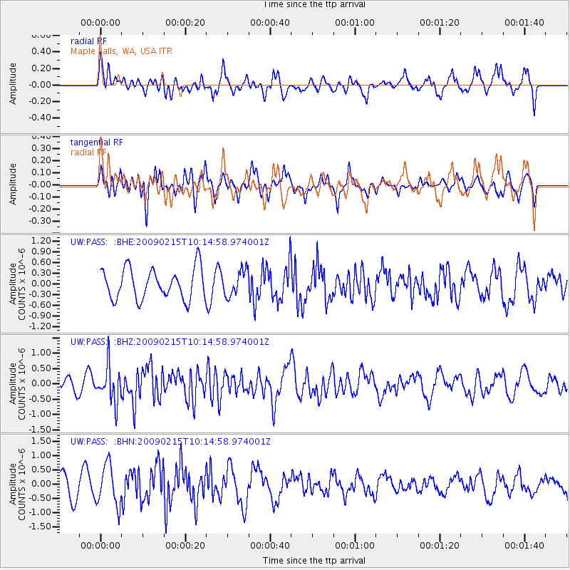
PASS Maple Falls, WA, USA - Earthquake Result Viewer
*The percent match for this event was below the threshold and hence no stack was calculated.
| Earthquake location: |
Near Coast Of Northern Peru |
| Earthquake latitude/longitude: |
-5.9/-80.9 |
| Earthquake time(UTC): |
2009/02/15 (046) 10:04:49 GMT |
| Earthquake Depth: |
21 km |
| Earthquake Magnitude: |
5.8 MB, 5.7 MS, 6.1 MW, 6.1 MW |
| Earthquake Catalog/Contributor: |
WHDF/NEIC |
|
| Network: |
UW Pacific Northwest Regional Seismic Network |
| Station: |
PASS Maple Falls, WA, USA |
| Lat/Lon: |
49.00 N/122.09 W |
| Elevation: |
174 m |
|
| Distance: |
65.4 deg |
| Az: |
331.499 deg |
| Baz: |
133.878 deg |
| Ray Param: |
$rayparam |
*The percent match for this event was below the threshold and hence was not used in the summary stack. |
|
| Radial Match: |
61.82756 % |
| Radial Bump: |
400 |
| Transverse Match: |
45.80899 % |
| Transverse Bump: |
400 |
| SOD ConfigId: |
2658 |
| Insert Time: |
2010-02-27 04:58:33.225 +0000 |
| GWidth: |
2.5 |
| Max Bumps: |
400 |
| Tol: |
0.001 |
|
Signal To Noise
| Channel | StoN | STA | LTA |
| UW:PASS: :BHZ:20090215T10:14:58.974001Z | 1.7877452 | 6.002124E-7 | 3.3573707E-7 |
| UW:PASS: :BHN:20090215T10:14:58.974001Z | 2.0518885 | 7.2096105E-7 | 3.5136466E-7 |
| UW:PASS: :BHE:20090215T10:14:58.974001Z | 0.84549344 | 3.6057966E-7 | 4.2647244E-7 |
| Arrivals |
| Ps | |
| PpPs | |
| PsPs/PpSs | |


