You are here: Home > Network List > UW - Pacific Northwest Regional Seismic Network Stations List
> Station PASS Maple Falls, WA, USA > Earthquake Result Viewer
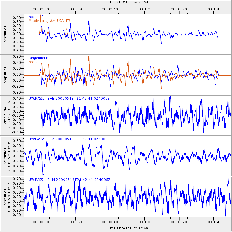
PASS Maple Falls, WA, USA - Earthquake Result Viewer
*The percent match for this event was below the threshold and hence no stack was calculated.
| Earthquake location: |
Tonga Islands |
| Earthquake latitude/longitude: |
-15.8/-173.5 |
| Earthquake time(UTC): |
2009/05/13 (133) 21:31:17 GMT |
| Earthquake Depth: |
85 km |
| Earthquake Magnitude: |
5.8 MW, 5.3 MB, 5.8 MW |
| Earthquake Catalog/Contributor: |
WHDF/NEIC |
|
| Network: |
UW Pacific Northwest Regional Seismic Network |
| Station: |
PASS Maple Falls, WA, USA |
| Lat/Lon: |
49.00 N/122.09 W |
| Elevation: |
174 m |
|
| Distance: |
78.9 deg |
| Az: |
31.638 deg |
| Baz: |
230.082 deg |
| Ray Param: |
$rayparam |
*The percent match for this event was below the threshold and hence was not used in the summary stack. |
|
| Radial Match: |
65.85077 % |
| Radial Bump: |
400 |
| Transverse Match: |
44.48731 % |
| Transverse Bump: |
400 |
| SOD ConfigId: |
2760 |
| Insert Time: |
2010-02-27 04:58:34.454 +0000 |
| GWidth: |
2.5 |
| Max Bumps: |
400 |
| Tol: |
0.001 |
|
Signal To Noise
| Channel | StoN | STA | LTA |
| UW:PASS: :BHZ:20090513T21:42:41.024006Z | 3.1026075 | 3.7360198E-7 | 1.2041548E-7 |
| UW:PASS: :BHN:20090513T21:42:41.024006Z | 1.2841672 | 1.5633553E-7 | 1.2174078E-7 |
| UW:PASS: :BHE:20090513T21:42:41.024006Z | 1.0597923 | 1.2736575E-7 | 1.2017992E-7 |
| Arrivals |
| Ps | |
| PpPs | |
| PsPs/PpSs | |


