You are here: Home > Network List > UW - Pacific Northwest Regional Seismic Network Stations List
> Station PASS Maple Falls, WA, USA > Earthquake Result Viewer
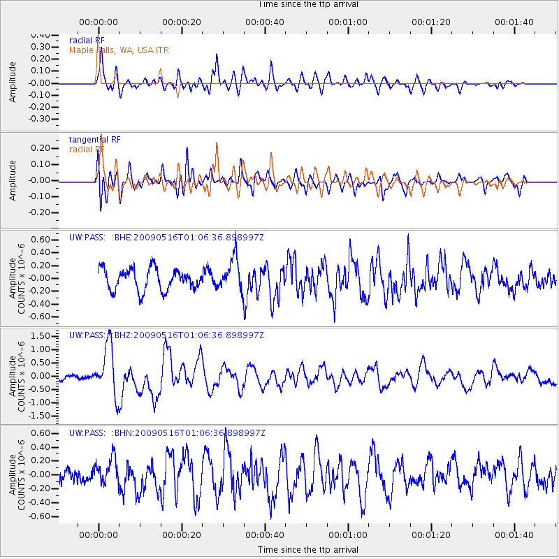
PASS Maple Falls, WA, USA - Earthquake Result Viewer
*The percent match for this event was below the threshold and hence no stack was calculated.
| Earthquake location: |
Kermadec Islands Region |
| Earthquake latitude/longitude: |
-31.5/-178.8 |
| Earthquake time(UTC): |
2009/05/16 (136) 00:53:52 GMT |
| Earthquake Depth: |
55 km |
| Earthquake Magnitude: |
6.1 MB, 6.5 MW, 6.3 MW |
| Earthquake Catalog/Contributor: |
WHDF/NEIC |
|
| Network: |
UW Pacific Northwest Regional Seismic Network |
| Station: |
PASS Maple Falls, WA, USA |
| Lat/Lon: |
49.00 N/122.09 W |
| Elevation: |
174 m |
|
| Distance: |
94.7 deg |
| Az: |
33.531 deg |
| Baz: |
225.751 deg |
| Ray Param: |
$rayparam |
*The percent match for this event was below the threshold and hence was not used in the summary stack. |
|
| Radial Match: |
83.066376 % |
| Radial Bump: |
400 |
| Transverse Match: |
67.837105 % |
| Transverse Bump: |
400 |
| SOD ConfigId: |
2760 |
| Insert Time: |
2010-02-27 04:58:38.349 +0000 |
| GWidth: |
2.5 |
| Max Bumps: |
400 |
| Tol: |
0.001 |
|
Signal To Noise
| Channel | StoN | STA | LTA |
| UW:PASS: :BHZ:20090516T01:06:36.898997Z | 8.023682 | 9.780337E-7 | 1.2189336E-7 |
| UW:PASS: :BHN:20090516T01:06:36.898997Z | 2.0474775 | 1.9540839E-7 | 9.543861E-8 |
| UW:PASS: :BHE:20090516T01:06:36.898997Z | 1.6081177 | 2.6401136E-7 | 1.6417414E-7 |
| Arrivals |
| Ps | |
| PpPs | |
| PsPs/PpSs | |


