You are here: Home > Network List > PO - Portable Observatories for Lithospheric Analysis and Research Investigating Seis Stations List
> Station BMRO Maryville Lake, ON, CANADA.A > Earthquake Result Viewer
BMRO Maryville Lake, ON, CANADA.A - Earthquake Result Viewer
| Earthquake location: |
El Salvador |
| Earthquake latitude/longitude: |
13.3/-89.2 |
| Earthquake time(UTC): |
2013/07/08 (189) 02:52:42 GMT |
| Earthquake Depth: |
55 km |
| Earthquake Magnitude: |
5.7 MW, 5.7 MB, 5.7 MW |
| Earthquake Catalog/Contributor: |
NEIC PDE/NEIC PDE-W |
|
| Network: |
PO Portable Observatories for Lithospheric Analysis and Research Investigating Seis |
| Station: |
BMRO Maryville Lake, ON, CANADA.A |
| Lat/Lon: |
44.60 N/81.22 W |
| Elevation: |
217 m |
|
| Distance: |
31.9 deg |
| Az: |
10.774 deg |
| Baz: |
194.758 deg |
| Ray Param: |
0.07874921 |
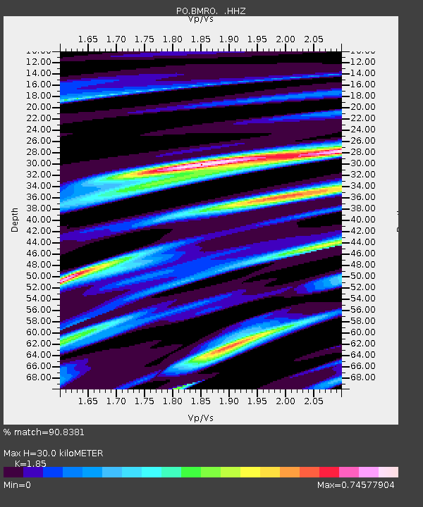
| Estimated Moho Depth: |
30.0 km |
| Estimated Crust Vp/Vs: |
1.85 |
| Assumed Crust Vp: |
6.53 km/s |
| Estimated Crust Vs: |
3.53 km/s |
| Estimated Crust Poisson's Ratio: |
0.29 |
|
| Radial Match: |
90.8381 % |
| Radial Bump: |
255 |
| Transverse Match: |
58.920433 % |
| Transverse Bump: |
400 |
| SOD ConfigId: |
512894 |
| Insert Time: |
2013-09-15 16:42:12.056 +0000 |
| GWidth: |
2.5 |
| Max Bumps: |
400 |
| Tol: |
0.001 |
|

Signal To Noise
| Channel | StoN | STA | LTA |
| PO:BMRO: :HHZ:20130708T02:58:33.040012Z | 7.210465 | 5.909773E-7 | 8.1961055E-8 |
| PO:BMRO: :HHN:20130708T02:58:33.040012Z | 5.268612 | 3.1204235E-7 | 5.922667E-8 |
| PO:BMRO: :HHE:20130708T02:58:33.040012Z | 2.1083663 | 1.9276017E-7 | 9.142632E-8 |
| Arrivals |
| Ps | 4.2 SECOND |
| PpPs | 12 SECOND |
| PsPs/PpSs | 16 SECOND |


