You are here: Home > Network List > PO - Portable Observatories for Lithospheric Analysis and Research Investigating Seis Stations List
> Station MATQ Matagami, QC > Earthquake Result Viewer
MATQ Matagami, QC - Earthquake Result Viewer
| Earthquake location: |
El Salvador |
| Earthquake latitude/longitude: |
13.3/-89.2 |
| Earthquake time(UTC): |
2013/07/08 (189) 02:52:42 GMT |
| Earthquake Depth: |
55 km |
| Earthquake Magnitude: |
5.7 MW, 5.7 MB, 5.7 MW |
| Earthquake Catalog/Contributor: |
NEIC PDE/NEIC PDE-W |
|
| Network: |
PO Portable Observatories for Lithospheric Analysis and Research Investigating Seis |
| Station: |
MATQ Matagami, QC |
| Lat/Lon: |
49.76 N/77.64 W |
| Elevation: |
280 m |
|
| Distance: |
37.6 deg |
| Az: |
12.277 deg |
| Baz: |
198.615 deg |
| Ray Param: |
0.07590666 |
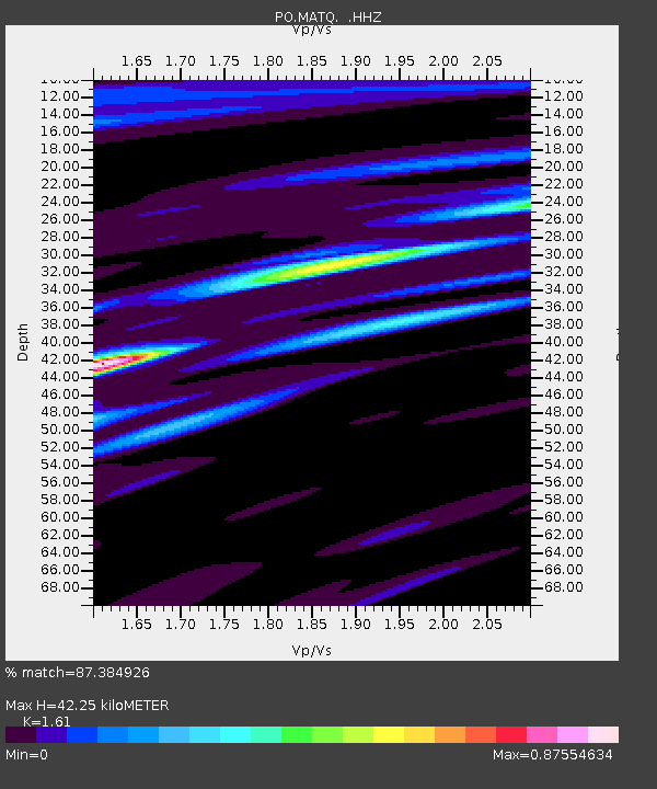
| Estimated Moho Depth: |
42.25 km |
| Estimated Crust Vp/Vs: |
1.61 |
| Assumed Crust Vp: |
6.61 km/s |
| Estimated Crust Vs: |
4.106 km/s |
| Estimated Crust Poisson's Ratio: |
0.19 |
|
| Radial Match: |
87.384926 % |
| Radial Bump: |
279 |
| Transverse Match: |
73.04357 % |
| Transverse Bump: |
400 |
| SOD ConfigId: |
512894 |
| Insert Time: |
2013-09-15 16:42:59.268 +0000 |
| GWidth: |
2.5 |
| Max Bumps: |
400 |
| Tol: |
0.001 |
|

Signal To Noise
| Channel | StoN | STA | LTA |
| PO:MATQ: :HHZ:20130708T02:59:21.60001Z | 7.609694 | 3.3305608E-7 | 4.376734E-8 |
| PO:MATQ: :HHN:20130708T02:59:21.60001Z | 6.756901 | 2.1505544E-7 | 3.1827526E-8 |
| PO:MATQ: :HHE:20130708T02:59:21.60001Z | 1.7348554 | 5.7340714E-8 | 3.3052157E-8 |
| Arrivals |
| Ps | 4.2 SECOND |
| PpPs | 15 SECOND |
| PsPs/PpSs | 20 SECOND |


