You are here: Home > Network List > UW - Pacific Northwest Regional Seismic Network Stations List
> Station PASS Maple Falls, WA, USA > Earthquake Result Viewer
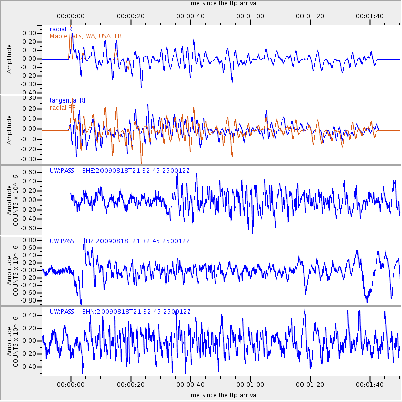
PASS Maple Falls, WA, USA - Earthquake Result Viewer
*The percent match for this event was below the threshold and hence no stack was calculated.
| Earthquake location: |
South Of Fiji Islands |
| Earthquake latitude/longitude: |
-26.1/-178.4 |
| Earthquake time(UTC): |
2009/08/18 (230) 21:20:47 GMT |
| Earthquake Depth: |
270 km |
| Earthquake Magnitude: |
5.5 MB, 6.3 MW, 6.3 MW |
| Earthquake Catalog/Contributor: |
WHDF/NEIC |
|
| Network: |
UW Pacific Northwest Regional Seismic Network |
| Station: |
PASS Maple Falls, WA, USA |
| Lat/Lon: |
49.00 N/122.09 W |
| Elevation: |
174 m |
|
| Distance: |
90.0 deg |
| Az: |
33.227 deg |
| Baz: |
228.449 deg |
| Ray Param: |
$rayparam |
*The percent match for this event was below the threshold and hence was not used in the summary stack. |
|
| Radial Match: |
53.286015 % |
| Radial Bump: |
400 |
| Transverse Match: |
59.849045 % |
| Transverse Bump: |
400 |
| SOD ConfigId: |
2622 |
| Insert Time: |
2010-02-27 04:58:47.451 +0000 |
| GWidth: |
2.5 |
| Max Bumps: |
400 |
| Tol: |
0.001 |
|
Signal To Noise
| Channel | StoN | STA | LTA |
| UW:PASS: :BHZ:20090818T21:32:45.250012Z | 6.082984 | 4.5629864E-7 | 7.50123E-8 |
| UW:PASS: :BHN:20090818T21:32:45.250012Z | 1.8357918 | 1.700351E-7 | 9.26222E-8 |
| UW:PASS: :BHE:20090818T21:32:45.250012Z | 1.6282896 | 1.6783201E-7 | 1.0307259E-7 |
| Arrivals |
| Ps | |
| PpPs | |
| PsPs/PpSs | |


