You are here: Home > Network List > PO - Portable Observatories for Lithospheric Analysis and Research Investigating Seis Stations List
> Station PEMO PEMBROKE, ON > Earthquake Result Viewer
PEMO PEMBROKE, ON - Earthquake Result Viewer
| Earthquake location: |
El Salvador |
| Earthquake latitude/longitude: |
13.3/-89.2 |
| Earthquake time(UTC): |
2013/07/08 (189) 02:52:42 GMT |
| Earthquake Depth: |
55 km |
| Earthquake Magnitude: |
5.7 MW, 5.7 MB, 5.7 MW |
| Earthquake Catalog/Contributor: |
NEIC PDE/NEIC PDE-W |
|
| Network: |
PO Portable Observatories for Lithospheric Analysis and Research Investigating Seis |
| Station: |
PEMO PEMBROKE, ON |
| Lat/Lon: |
45.68 N/77.25 W |
| Elevation: |
180 m |
|
| Distance: |
33.8 deg |
| Az: |
15.084 deg |
| Baz: |
201.184 deg |
| Ray Param: |
0.07790209 |
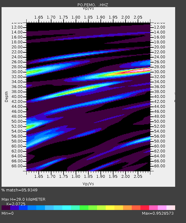
| Estimated Moho Depth: |
29.0 km |
| Estimated Crust Vp/Vs: |
2.07 |
| Assumed Crust Vp: |
6.577 km/s |
| Estimated Crust Vs: |
3.173 km/s |
| Estimated Crust Poisson's Ratio: |
0.35 |
|
| Radial Match: |
85.9349 % |
| Radial Bump: |
312 |
| Transverse Match: |
58.788822 % |
| Transverse Bump: |
400 |
| SOD ConfigId: |
512894 |
| Insert Time: |
2013-09-15 16:43:15.260 +0000 |
| GWidth: |
2.5 |
| Max Bumps: |
400 |
| Tol: |
0.001 |
|

Signal To Noise
| Channel | StoN | STA | LTA |
| PO:PEMO: :HHZ:20130708T02:58:49.549991Z | 7.089085 | 2.5734684E-7 | 3.630184E-8 |
| PO:PEMO: :HHN:20130708T02:58:49.549991Z | 5.805837 | 1.5597037E-7 | 2.6864408E-8 |
| PO:PEMO: :HHE:20130708T02:58:49.549991Z | 2.4183118 | 6.974708E-8 | 2.884123E-8 |
| Arrivals |
| Ps | 5.1 SECOND |
| PpPs | 13 SECOND |
| PsPs/PpSs | 18 SECOND |


