You are here: Home > Network List > TA - USArray Transportable Network (new EarthScope stations) Stations List
> Station E46A Sault Ste Marie, MI, USA > Earthquake Result Viewer
E46A Sault Ste Marie, MI, USA - Earthquake Result Viewer
| Earthquake location: |
El Salvador |
| Earthquake latitude/longitude: |
13.3/-89.2 |
| Earthquake time(UTC): |
2013/07/08 (189) 02:52:42 GMT |
| Earthquake Depth: |
55 km |
| Earthquake Magnitude: |
5.7 MW, 5.7 MB, 5.7 MW |
| Earthquake Catalog/Contributor: |
NEIC PDE/NEIC PDE-W |
|
| Network: |
TA USArray Transportable Network (new EarthScope stations) |
| Station: |
E46A Sault Ste Marie, MI, USA |
| Lat/Lon: |
46.37 N/84.31 W |
| Elevation: |
269 m |
|
| Distance: |
33.2 deg |
| Az: |
6.154 deg |
| Baz: |
188.668 deg |
| Ray Param: |
0.07817918 |
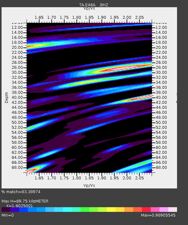
| Estimated Moho Depth: |
69.75 km |
| Estimated Crust Vp/Vs: |
1.60 |
| Assumed Crust Vp: |
6.467 km/s |
| Estimated Crust Vs: |
4.035 km/s |
| Estimated Crust Poisson's Ratio: |
0.18 |
|
| Radial Match: |
83.38974 % |
| Radial Bump: |
400 |
| Transverse Match: |
50.11071 % |
| Transverse Bump: |
400 |
| SOD ConfigId: |
512894 |
| Insert Time: |
2013-09-15 16:45:37.130 +0000 |
| GWidth: |
2.5 |
| Max Bumps: |
400 |
| Tol: |
0.001 |
|

Signal To Noise
| Channel | StoN | STA | LTA |
| TA:E46A: :BHZ:20130708T02:58:44.324985Z | 5.777072 | 6.2897664E-7 | 1.0887464E-7 |
| TA:E46A: :BHN:20130708T02:58:44.324985Z | 2.6266735 | 3.196765E-7 | 1.2170393E-7 |
| TA:E46A: :BHE:20130708T02:58:44.324985Z | 2.337815 | 1.8325879E-7 | 7.838892E-8 |
| Arrivals |
| Ps | 7.1 SECOND |
| PpPs | 26 SECOND |
| PsPs/PpSs | 33 SECOND |


