You are here: Home > Network List > TA - USArray Transportable Network (new EarthScope stations) Stations List
> Station H17A Grant Village (NPS), Yellowstone Nt. Park, WY, USA > Earthquake Result Viewer
H17A Grant Village (NPS), Yellowstone Nt. Park, WY, USA - Earthquake Result Viewer
| Earthquake location: |
El Salvador |
| Earthquake latitude/longitude: |
13.3/-89.2 |
| Earthquake time(UTC): |
2013/07/08 (189) 02:52:42 GMT |
| Earthquake Depth: |
55 km |
| Earthquake Magnitude: |
5.7 MW, 5.7 MB, 5.7 MW |
| Earthquake Catalog/Contributor: |
NEIC PDE/NEIC PDE-W |
|
| Network: |
TA USArray Transportable Network (new EarthScope stations) |
| Station: |
H17A Grant Village (NPS), Yellowstone Nt. Park, WY, USA |
| Lat/Lon: |
44.40 N/110.58 W |
| Elevation: |
2400 m |
|
| Distance: |
36.0 deg |
| Az: |
333.569 deg |
| Baz: |
142.807 deg |
| Ray Param: |
0.07677506 |
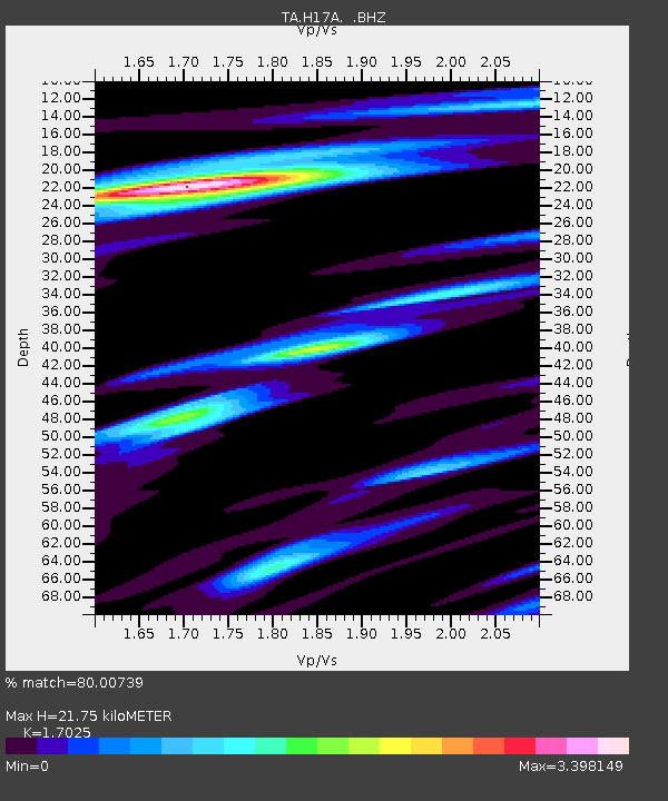
| Estimated Moho Depth: |
21.75 km |
| Estimated Crust Vp/Vs: |
1.70 |
| Assumed Crust Vp: |
6.35 km/s |
| Estimated Crust Vs: |
3.73 km/s |
| Estimated Crust Poisson's Ratio: |
0.24 |
|
| Radial Match: |
80.00739 % |
| Radial Bump: |
400 |
| Transverse Match: |
77.17571 % |
| Transverse Bump: |
400 |
| SOD ConfigId: |
512894 |
| Insert Time: |
2013-09-15 16:47:22.727 +0000 |
| GWidth: |
2.5 |
| Max Bumps: |
400 |
| Tol: |
0.001 |
|
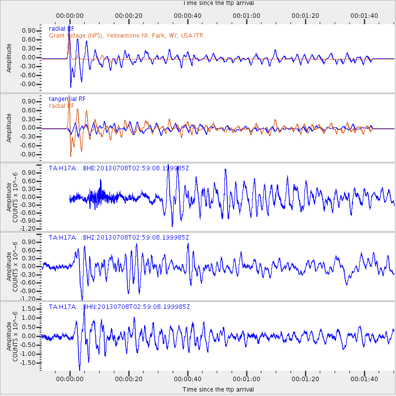
Signal To Noise
| Channel | StoN | STA | LTA |
| TA:H17A: :BHZ:20130708T02:59:08.199985Z | 5.481625 | 4.965298E-7 | 9.058077E-8 |
| TA:H17A: :BHN:20130708T02:59:08.199985Z | 4.813025 | 7.229304E-7 | 1.5020292E-7 |
| TA:H17A: :BHE:20130708T02:59:08.199985Z | 3.8846087 | 4.875273E-7 | 1.255023E-7 |
| Arrivals |
| Ps | 2.6 SECOND |
| PpPs | 8.6 SECOND |
| PsPs/PpSs | 11 SECOND |


