You are here: Home > Network List > TA - USArray Transportable Network (new EarthScope stations) Stations List
> Station H45A Beulah, MI, USA > Earthquake Result Viewer
H45A Beulah, MI, USA - Earthquake Result Viewer
| Earthquake location: |
El Salvador |
| Earthquake latitude/longitude: |
13.3/-89.2 |
| Earthquake time(UTC): |
2013/07/08 (189) 02:52:42 GMT |
| Earthquake Depth: |
55 km |
| Earthquake Magnitude: |
5.7 MW, 5.7 MB, 5.7 MW |
| Earthquake Catalog/Contributor: |
NEIC PDE/NEIC PDE-W |
|
| Network: |
TA USArray Transportable Network (new EarthScope stations) |
| Station: |
H45A Beulah, MI, USA |
| Lat/Lon: |
44.62 N/86.04 W |
| Elevation: |
242 m |
|
| Distance: |
31.3 deg |
| Az: |
4.296 deg |
| Baz: |
185.862 deg |
| Ray Param: |
0.078999646 |
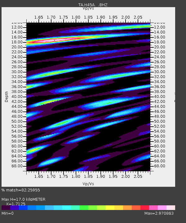
| Estimated Moho Depth: |
17.0 km |
| Estimated Crust Vp/Vs: |
1.71 |
| Assumed Crust Vp: |
6.53 km/s |
| Estimated Crust Vs: |
3.813 km/s |
| Estimated Crust Poisson's Ratio: |
0.24 |
|
| Radial Match: |
82.25955 % |
| Radial Bump: |
400 |
| Transverse Match: |
78.66299 % |
| Transverse Bump: |
400 |
| SOD ConfigId: |
512894 |
| Insert Time: |
2013-09-15 16:47:31.322 +0000 |
| GWidth: |
2.5 |
| Max Bumps: |
400 |
| Tol: |
0.001 |
|

Signal To Noise
| Channel | StoN | STA | LTA |
| TA:H45A: :BHZ:20130708T02:58:27.875004Z | 7.6883426 | 8.237449E-7 | 1.07142064E-7 |
| TA:H45A: :BHN:20130708T02:58:27.875004Z | 4.333308 | 6.623288E-7 | 1.52846E-7 |
| TA:H45A: :BHE:20130708T02:58:27.875004Z | 1.4297616 | 2.4631322E-7 | 1.7227572E-7 |
| Arrivals |
| Ps | 2.0 SECOND |
| PpPs | 6.5 SECOND |
| PsPs/PpSs | 8.5 SECOND |


