You are here: Home > Network List > TA - USArray Transportable Network (new EarthScope stations) Stations List
> Station H46A Fife Lake, MI, USA > Earthquake Result Viewer
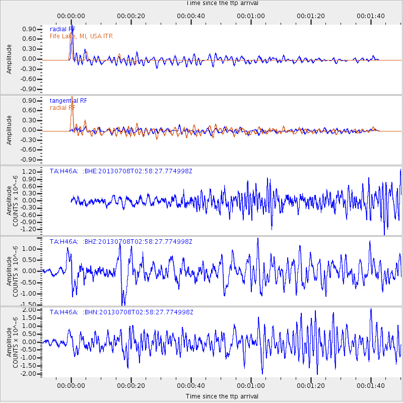
H46A Fife Lake, MI, USA - Earthquake Result Viewer
*The percent match for this event was below the threshold and hence no stack was calculated.
| Earthquake location: |
El Salvador |
| Earthquake latitude/longitude: |
13.3/-89.2 |
| Earthquake time(UTC): |
2013/07/08 (189) 02:52:42 GMT |
| Earthquake Depth: |
55 km |
| Earthquake Magnitude: |
5.7 MW, 5.7 MB, 5.7 MW |
| Earthquake Catalog/Contributor: |
NEIC PDE/NEIC PDE-W |
|
| Network: |
TA USArray Transportable Network (new EarthScope stations) |
| Station: |
H46A Fife Lake, MI, USA |
| Lat/Lon: |
44.54 N/85.20 W |
| Elevation: |
329 m |
|
| Distance: |
31.3 deg |
| Az: |
5.462 deg |
| Baz: |
187.446 deg |
| Ray Param: |
$rayparam |
*The percent match for this event was below the threshold and hence was not used in the summary stack. |
|
| Radial Match: |
71.22798 % |
| Radial Bump: |
400 |
| Transverse Match: |
49.879128 % |
| Transverse Bump: |
400 |
| SOD ConfigId: |
512894 |
| Insert Time: |
2013-09-15 16:47:36.926 +0000 |
| GWidth: |
2.5 |
| Max Bumps: |
400 |
| Tol: |
0.001 |
|
Signal To Noise
| Channel | StoN | STA | LTA |
| TA:H46A: :BHZ:20130708T02:58:27.774998Z | 5.4597955 | 5.529437E-7 | 1.0127552E-7 |
| TA:H46A: :BHN:20130708T02:58:27.774998Z | 4.3510475 | 4.98832E-7 | 1.1464642E-7 |
| TA:H46A: :BHE:20130708T02:58:27.774998Z | 1.0248538 | 1.2217309E-7 | 1.1921026E-7 |
| Arrivals |
| Ps | |
| PpPs | |
| PsPs/PpSs | |


