You are here: Home > Network List > UW - Pacific Northwest Regional Seismic Network Stations List
> Station PASS Maple Falls, WA, USA > Earthquake Result Viewer
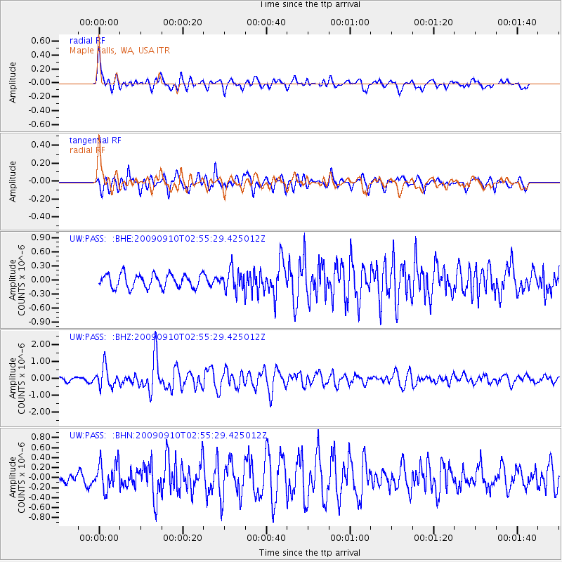
PASS Maple Falls, WA, USA - Earthquake Result Viewer
*The percent match for this event was below the threshold and hence no stack was calculated.
| Earthquake location: |
Kuril Islands |
| Earthquake latitude/longitude: |
48.3/154.2 |
| Earthquake time(UTC): |
2009/09/10 (253) 02:46:50 GMT |
| Earthquake Depth: |
36 km |
| Earthquake Magnitude: |
6.0 MB, 5.5 MS, 6.0 MW, 5.8 MW |
| Earthquake Catalog/Contributor: |
WHDF/NEIC |
|
| Network: |
UW Pacific Northwest Regional Seismic Network |
| Station: |
PASS Maple Falls, WA, USA |
| Lat/Lon: |
49.00 N/122.09 W |
| Elevation: |
174 m |
|
| Distance: |
52.5 deg |
| Az: |
55.574 deg |
| Baz: |
303.278 deg |
| Ray Param: |
$rayparam |
*The percent match for this event was below the threshold and hence was not used in the summary stack. |
|
| Radial Match: |
74.978645 % |
| Radial Bump: |
400 |
| Transverse Match: |
73.203094 % |
| Transverse Bump: |
400 |
| SOD ConfigId: |
2622 |
| Insert Time: |
2010-02-27 04:58:52.275 +0000 |
| GWidth: |
2.5 |
| Max Bumps: |
400 |
| Tol: |
0.001 |
|
Signal To Noise
| Channel | StoN | STA | LTA |
| UW:PASS: :BHZ:20090910T02:55:29.425012Z | 6.7205615 | 5.9999707E-7 | 8.927782E-8 |
| UW:PASS: :BHN:20090910T02:55:29.425012Z | 1.5368419 | 2.7672596E-7 | 1.8006145E-7 |
| UW:PASS: :BHE:20090910T02:55:29.425012Z | 1.5793059 | 2.2710549E-7 | 1.4380083E-7 |
| Arrivals |
| Ps | |
| PpPs | |
| PsPs/PpSs | |


