You are here: Home > Network List > TA - USArray Transportable Network (new EarthScope stations) Stations List
> Station I45A Fountain, MI, USA > Earthquake Result Viewer
I45A Fountain, MI, USA - Earthquake Result Viewer
| Earthquake location: |
El Salvador |
| Earthquake latitude/longitude: |
13.3/-89.2 |
| Earthquake time(UTC): |
2013/07/08 (189) 02:52:42 GMT |
| Earthquake Depth: |
55 km |
| Earthquake Magnitude: |
5.7 MW, 5.7 MB, 5.7 MW |
| Earthquake Catalog/Contributor: |
NEIC PDE/NEIC PDE-W |
|
| Network: |
TA USArray Transportable Network (new EarthScope stations) |
| Station: |
I45A Fountain, MI, USA |
| Lat/Lon: |
44.04 N/86.23 W |
| Elevation: |
215 m |
|
| Distance: |
30.7 deg |
| Az: |
4.146 deg |
| Baz: |
185.6 deg |
| Ray Param: |
0.07917835 |
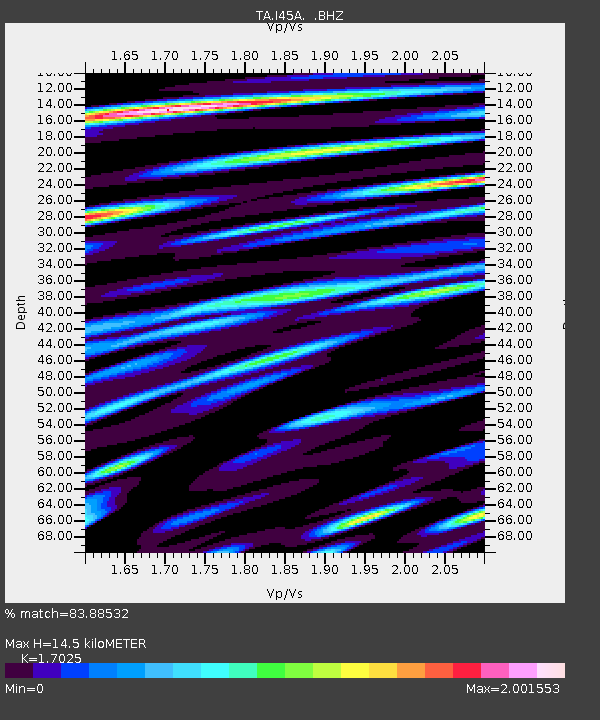
| Estimated Moho Depth: |
14.5 km |
| Estimated Crust Vp/Vs: |
1.70 |
| Assumed Crust Vp: |
6.53 km/s |
| Estimated Crust Vs: |
3.836 km/s |
| Estimated Crust Poisson's Ratio: |
0.24 |
|
| Radial Match: |
83.88532 % |
| Radial Bump: |
400 |
| Transverse Match: |
66.98268 % |
| Transverse Bump: |
400 |
| SOD ConfigId: |
512894 |
| Insert Time: |
2013-09-15 16:48:25.116 +0000 |
| GWidth: |
2.5 |
| Max Bumps: |
400 |
| Tol: |
0.001 |
|
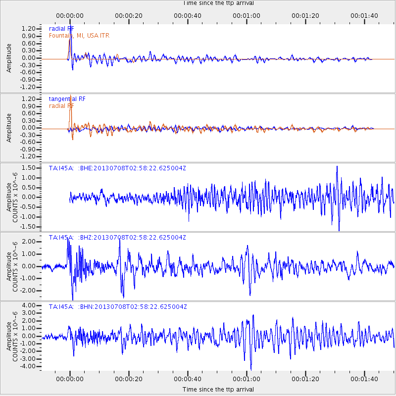
Signal To Noise
| Channel | StoN | STA | LTA |
| TA:I45A: :BHZ:20130708T02:58:22.625004Z | 11.775122 | 1.2366509E-6 | 1.0502235E-7 |
| TA:I45A: :BHN:20130708T02:58:22.625004Z | 5.9741178 | 8.8875396E-7 | 1.487674E-7 |
| TA:I45A: :BHE:20130708T02:58:22.625004Z | 1.1906133 | 1.7815992E-7 | 1.4963712E-7 |
| Arrivals |
| Ps | 1.7 SECOND |
| PpPs | 5.5 SECOND |
| PsPs/PpSs | 7.2 SECOND |


