You are here: Home > Network List > TA - USArray Transportable Network (new EarthScope stations) Stations List
> Station J54A Appleton, NY, USA > Earthquake Result Viewer
J54A Appleton, NY, USA - Earthquake Result Viewer
| Earthquake location: |
El Salvador |
| Earthquake latitude/longitude: |
13.3/-89.2 |
| Earthquake time(UTC): |
2013/07/08 (189) 02:52:42 GMT |
| Earthquake Depth: |
55 km |
| Earthquake Magnitude: |
5.7 MW, 5.7 MB, 5.7 MW |
| Earthquake Catalog/Contributor: |
NEIC PDE/NEIC PDE-W |
|
| Network: |
TA USArray Transportable Network (new EarthScope stations) |
| Station: |
J54A Appleton, NY, USA |
| Lat/Lon: |
43.27 N/78.64 W |
| Elevation: |
112 m |
|
| Distance: |
31.2 deg |
| Az: |
14.924 deg |
| Baz: |
200.077 deg |
| Ray Param: |
0.079047926 |
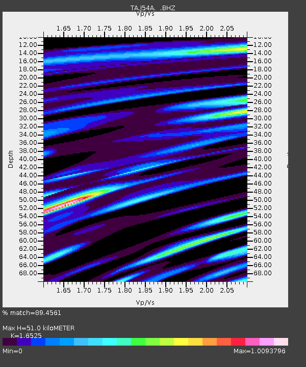
| Estimated Moho Depth: |
51.0 km |
| Estimated Crust Vp/Vs: |
1.65 |
| Assumed Crust Vp: |
6.419 km/s |
| Estimated Crust Vs: |
3.885 km/s |
| Estimated Crust Poisson's Ratio: |
0.21 |
|
| Radial Match: |
89.4561 % |
| Radial Bump: |
400 |
| Transverse Match: |
64.19439 % |
| Transverse Bump: |
400 |
| SOD ConfigId: |
512894 |
| Insert Time: |
2013-09-15 16:49:20.832 +0000 |
| GWidth: |
2.5 |
| Max Bumps: |
400 |
| Tol: |
0.001 |
|

Signal To Noise
| Channel | StoN | STA | LTA |
| TA:J54A: :BHZ:20130708T02:58:26.875004Z | 8.065495 | 7.383277E-7 | 9.154153E-8 |
| TA:J54A: :BHN:20130708T02:58:26.875004Z | 4.775514 | 5.197245E-7 | 1.088311E-7 |
| TA:J54A: :BHE:20130708T02:58:26.875004Z | 1.6215929 | 1.7131754E-7 | 1.0564769E-7 |
| Arrivals |
| Ps | 5.6 SECOND |
| PpPs | 19 SECOND |
| PsPs/PpSs | 25 SECOND |


