You are here: Home > Network List > UW - Pacific Northwest Regional Seismic Network Stations List
> Station UMAT Pilot Rock, OR, USA > Earthquake Result Viewer
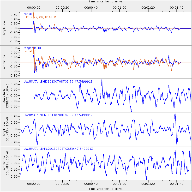
UMAT Pilot Rock, OR, USA - Earthquake Result Viewer
*The percent match for this event was below the threshold and hence no stack was calculated.
| Earthquake location: |
El Salvador |
| Earthquake latitude/longitude: |
13.3/-89.2 |
| Earthquake time(UTC): |
2013/07/08 (189) 02:52:42 GMT |
| Earthquake Depth: |
55 km |
| Earthquake Magnitude: |
5.7 MW, 5.7 MB, 5.7 MW |
| Earthquake Catalog/Contributor: |
NEIC PDE/NEIC PDE-W |
|
| Network: |
UW Pacific Northwest Regional Seismic Network |
| Station: |
UMAT Pilot Rock, OR, USA |
| Lat/Lon: |
45.29 N/118.96 W |
| Elevation: |
1318 m |
|
| Distance: |
40.7 deg |
| Az: |
327.462 deg |
| Baz: |
132.114 deg |
| Ray Param: |
$rayparam |
*The percent match for this event was below the threshold and hence was not used in the summary stack. |
|
| Radial Match: |
48.631546 % |
| Radial Bump: |
396 |
| Transverse Match: |
60.94453 % |
| Transverse Bump: |
400 |
| SOD ConfigId: |
512894 |
| Insert Time: |
2013-09-15 16:55:10.809 +0000 |
| GWidth: |
2.5 |
| Max Bumps: |
400 |
| Tol: |
0.001 |
|
Signal To Noise
| Channel | StoN | STA | LTA |
| UW:UMAT: :BHZ:20130708T02:59:47.549991Z | 4.0423994 | 2.3409011E-7 | 5.7908704E-8 |
| UW:UMAT: :BHN:20130708T02:59:47.549991Z | 1.40393 | 7.3552606E-8 | 5.239051E-8 |
| UW:UMAT: :BHE:20130708T02:59:47.549991Z | 3.0523317 | 1.3509154E-7 | 4.4258474E-8 |
| Arrivals |
| Ps | |
| PpPs | |
| PsPs/PpSs | |


