You are here: Home > Network List > UW - Pacific Northwest Regional Seismic Network Stations List
> Station PASS Maple Falls, WA, USA > Earthquake Result Viewer
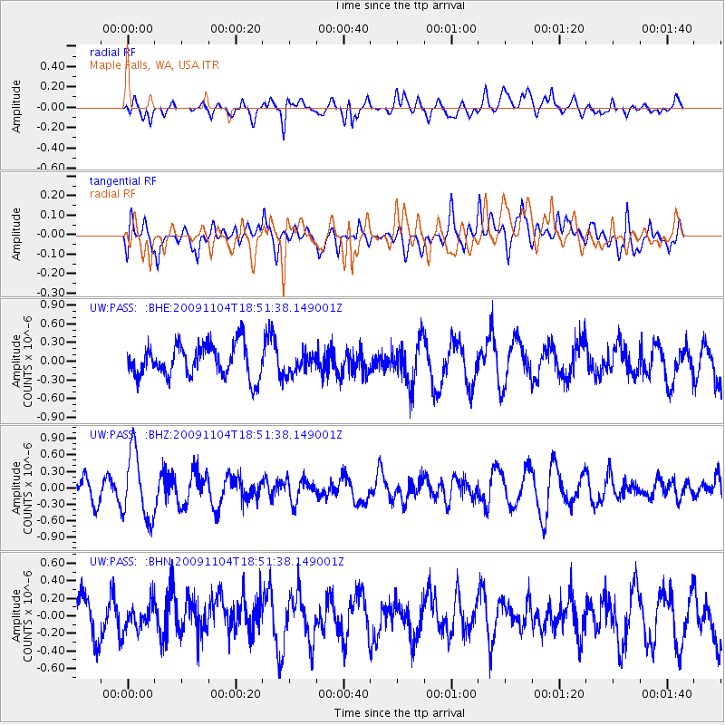
PASS Maple Falls, WA, USA - Earthquake Result Viewer
*The percent match for this event was below the threshold and hence no stack was calculated.
| Earthquake location: |
Azores Islands Region |
| Earthquake latitude/longitude: |
36.2/-33.9 |
| Earthquake time(UTC): |
2009/11/04 (308) 18:41:44 GMT |
| Earthquake Depth: |
10 km |
| Earthquake Magnitude: |
5.7 MB, 5.6 MS, 5.9 MW, 5.8 MW |
| Earthquake Catalog/Contributor: |
WHDF/NEIC |
|
| Network: |
UW Pacific Northwest Regional Seismic Network |
| Station: |
PASS Maple Falls, WA, USA |
| Lat/Lon: |
49.00 N/122.09 W |
| Elevation: |
174 m |
|
| Distance: |
62.7 deg |
| Az: |
312.203 deg |
| Baz: |
65.548 deg |
| Ray Param: |
$rayparam |
*The percent match for this event was below the threshold and hence was not used in the summary stack. |
|
| Radial Match: |
45.612164 % |
| Radial Bump: |
400 |
| Transverse Match: |
46.917473 % |
| Transverse Bump: |
400 |
| SOD ConfigId: |
2622 |
| Insert Time: |
2010-02-27 04:59:17.442 +0000 |
| GWidth: |
2.5 |
| Max Bumps: |
400 |
| Tol: |
0.001 |
|
Signal To Noise
| Channel | StoN | STA | LTA |
| UW:PASS: :BHZ:20091104T18:51:38.149001Z | 2.9394052 | 6.1228417E-7 | 2.0830207E-7 |
| UW:PASS: :BHN:20091104T18:51:38.149001Z | 0.5429061 | 1.366872E-7 | 2.517695E-7 |
| UW:PASS: :BHE:20091104T18:51:38.149001Z | 0.6244286 | 1.6093175E-7 | 2.5772644E-7 |
| Arrivals |
| Ps | |
| PpPs | |
| PsPs/PpSs | |


