You are here: Home > Network List > GO - National Seismic Network of Georgia Stations List
> Station TBLG Delisi, Georgia > Earthquake Result Viewer
TBLG Delisi, Georgia - Earthquake Result Viewer
| Earthquake location: |
Southern Sumatra, Indonesia |
| Earthquake latitude/longitude: |
-3.4/100.5 |
| Earthquake time(UTC): |
2013/07/09 (190) 17:04:15 GMT |
| Earthquake Depth: |
18 km |
| Earthquake Magnitude: |
5.5 MW, 5.6 MW, 5.6 MB |
| Earthquake Catalog/Contributor: |
NEIC PDE/NEIC PDE-W |
|
| Network: |
GO National Seismic Network of Georgia |
| Station: |
TBLG Delisi, Georgia |
| Lat/Lon: |
41.73 N/44.74 E |
| Elevation: |
510 m |
|
| Distance: |
67.5 deg |
| Az: |
317.986 deg |
| Baz: |
116.786 deg |
| Ray Param: |
0.05688397 |
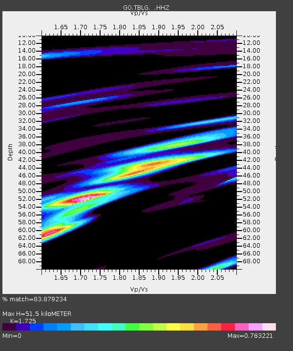
| Estimated Moho Depth: |
51.5 km |
| Estimated Crust Vp/Vs: |
1.73 |
| Assumed Crust Vp: |
6.291 km/s |
| Estimated Crust Vs: |
3.647 km/s |
| Estimated Crust Poisson's Ratio: |
0.25 |
|
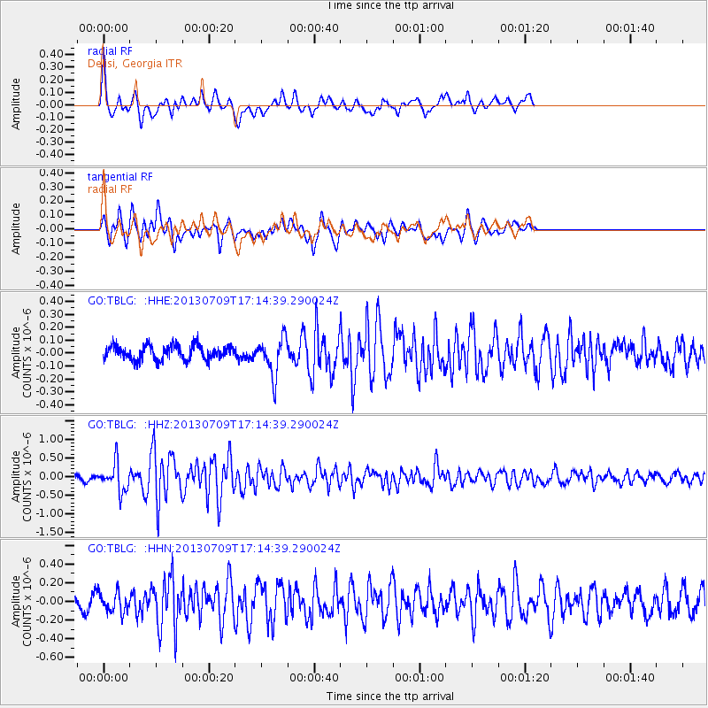
| Radial Match: |
83.879234 % |
| Radial Bump: |
400 |
| Transverse Match: |
81.713005 % |
| Transverse Bump: |
400 |
| SOD ConfigId: |
512894 |
| Insert Time: |
2013-09-15 17:13:11.430 +0000 |
| GWidth: |
2.5 |
| Max Bumps: |
400 |
| Tol: |
0.001 |
|
Signal To Noise
| Channel | StoN | STA | LTA |
| GO:TBLG: :HHZ:20130709T17:14:39.290024Z | 5.398553 | 3.7149184E-7 | 6.881323E-8 |
| GO:TBLG: :HHN:20130709T17:14:39.290024Z | 1.9218199 | 1.0741599E-7 | 5.589285E-8 |
| GO:TBLG: :HHE:20130709T17:14:39.290024Z | 2.6203485 | 1.4617062E-7 | 5.578289E-8 |
| Arrivals |
| Ps | 6.2 SECOND |
| PpPs | 21 SECOND |
| PsPs/PpSs | 28 SECOND |


