You are here: Home > Network List > UW - Pacific Northwest Regional Seismic Network Stations List
> Station PASS Maple Falls, WA, USA > Earthquake Result Viewer
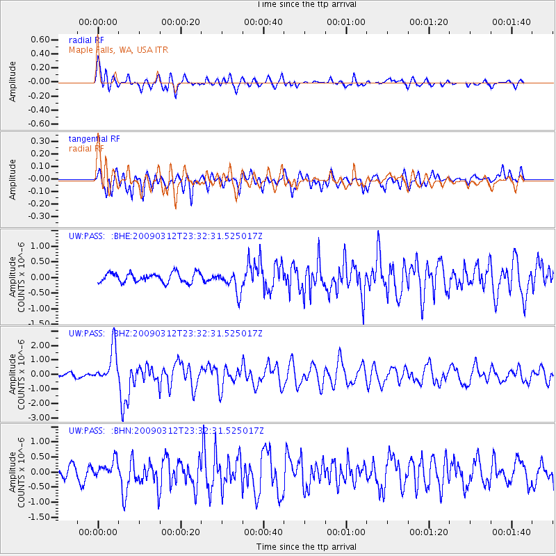
PASS Maple Falls, WA, USA - Earthquake Result Viewer
*The percent match for this event was below the threshold and hence no stack was calculated.
| Earthquake location: |
South Of Panama |
| Earthquake latitude/longitude: |
5.7/-82.8 |
| Earthquake time(UTC): |
2009/03/12 (071) 23:23:34 GMT |
| Earthquake Depth: |
9.0 km |
| Earthquake Magnitude: |
6.1 MB, 5.9 MS, 6.3 MW, 6.2 MW |
| Earthquake Catalog/Contributor: |
WHDF/NEIC |
|
| Network: |
UW Pacific Northwest Regional Seismic Network |
| Station: |
PASS Maple Falls, WA, USA |
| Lat/Lon: |
49.00 N/122.09 W |
| Elevation: |
174 m |
|
| Distance: |
54.5 deg |
| Az: |
329.152 deg |
| Baz: |
129.214 deg |
| Ray Param: |
$rayparam |
*The percent match for this event was below the threshold and hence was not used in the summary stack. |
|
| Radial Match: |
71.385345 % |
| Radial Bump: |
400 |
| Transverse Match: |
69.72099 % |
| Transverse Bump: |
400 |
| SOD ConfigId: |
2658 |
| Insert Time: |
2010-02-27 04:59:27.686 +0000 |
| GWidth: |
2.5 |
| Max Bumps: |
400 |
| Tol: |
0.001 |
|
Signal To Noise
| Channel | StoN | STA | LTA |
| UW:PASS: :BHZ:20090312T23:32:31.525017Z | 6.573308 | 1.2633607E-6 | 1.9219556E-7 |
| UW:PASS: :BHN:20090312T23:32:31.525017Z | 1.7982122 | 2.9433753E-7 | 1.6368342E-7 |
| UW:PASS: :BHE:20090312T23:32:31.525017Z | 2.4070456 | 3.652824E-7 | 1.5175551E-7 |
| Arrivals |
| Ps | |
| PpPs | |
| PsPs/PpSs | |


