You are here: Home > Network List > UW - Pacific Northwest Regional Seismic Network Stations List
> Station PASS Maple Falls, WA, USA > Earthquake Result Viewer
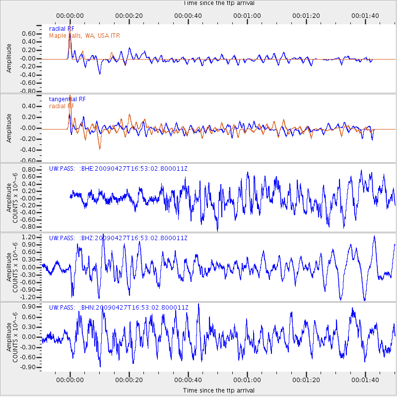
PASS Maple Falls, WA, USA - Earthquake Result Viewer
*The percent match for this event was below the threshold and hence no stack was calculated.
| Earthquake location: |
Guerrero, Mexico |
| Earthquake latitude/longitude: |
17.0/-99.4 |
| Earthquake time(UTC): |
2009/04/27 (117) 16:46:28 GMT |
| Earthquake Depth: |
35 km |
| Earthquake Magnitude: |
5.7 MB, 5.4 MS, 5.8 MW, 5.8 MW |
| Earthquake Catalog/Contributor: |
WHDF/NEIC |
|
| Network: |
UW Pacific Northwest Regional Seismic Network |
| Station: |
PASS Maple Falls, WA, USA |
| Lat/Lon: |
49.00 N/122.09 W |
| Elevation: |
174 m |
|
| Distance: |
36.8 deg |
| Az: |
334.972 deg |
| Baz: |
142.081 deg |
| Ray Param: |
$rayparam |
*The percent match for this event was below the threshold and hence was not used in the summary stack. |
|
| Radial Match: |
71.58811 % |
| Radial Bump: |
400 |
| Transverse Match: |
45.72189 % |
| Transverse Bump: |
400 |
| SOD ConfigId: |
2658 |
| Insert Time: |
2010-02-27 04:59:39.809 +0000 |
| GWidth: |
2.5 |
| Max Bumps: |
400 |
| Tol: |
0.001 |
|
Signal To Noise
| Channel | StoN | STA | LTA |
| UW:PASS: :BHZ:20090427T16:53:02.800011Z | 4.905514 | 5.398002E-7 | 1.1003949E-7 |
| UW:PASS: :BHN:20090427T16:53:02.800011Z | 4.0147233 | 3.7099946E-7 | 9.240972E-8 |
| UW:PASS: :BHE:20090427T16:53:02.800011Z | 1.4035391 | 1.7073948E-7 | 1.2164925E-7 |
| Arrivals |
| Ps | |
| PpPs | |
| PsPs/PpSs | |


