You are here: Home > Network List > UW - Pacific Northwest Regional Seismic Network Stations List
> Station PASS Maple Falls, WA, USA > Earthquake Result Viewer
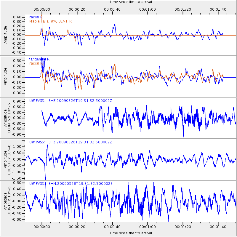
PASS Maple Falls, WA, USA - Earthquake Result Viewer
*The percent match for this event was below the threshold and hence no stack was calculated.
| Earthquake location: |
Northwest Of Ryukyu Islands |
| Earthquake latitude/longitude: |
27.4/126.7 |
| Earthquake time(UTC): |
2009/03/26 (085) 19:19:59 GMT |
| Earthquake Depth: |
160 km |
| Earthquake Magnitude: |
5.6 MB, 5.9 MW, 5.9 MW |
| Earthquake Catalog/Contributor: |
WHDF/NEIC |
|
| Network: |
UW Pacific Northwest Regional Seismic Network |
| Station: |
PASS Maple Falls, WA, USA |
| Lat/Lon: |
49.00 N/122.09 W |
| Elevation: |
174 m |
|
| Distance: |
82.4 deg |
| Az: |
38.276 deg |
| Baz: |
303.267 deg |
| Ray Param: |
$rayparam |
*The percent match for this event was below the threshold and hence was not used in the summary stack. |
|
| Radial Match: |
37.403866 % |
| Radial Bump: |
400 |
| Transverse Match: |
55.16859 % |
| Transverse Bump: |
400 |
| SOD ConfigId: |
2658 |
| Insert Time: |
2010-02-27 04:59:42.659 +0000 |
| GWidth: |
2.5 |
| Max Bumps: |
400 |
| Tol: |
0.001 |
|
Signal To Noise
| Channel | StoN | STA | LTA |
| UW:PASS: :BHZ:20090326T19:31:32.500002Z | 3.6659524 | 5.999785E-7 | 1.6366238E-7 |
| UW:PASS: :BHN:20090326T19:31:32.500002Z | 1.2247267 | 2.405921E-7 | 1.9644555E-7 |
| UW:PASS: :BHE:20090326T19:31:32.500002Z | 2.024194 | 3.6936032E-7 | 1.8247277E-7 |
| Arrivals |
| Ps | |
| PpPs | |
| PsPs/PpSs | |


