You are here: Home > Network List > UW - Pacific Northwest Regional Seismic Network Stations List
> Station PASS Maple Falls, WA, USA > Earthquake Result Viewer
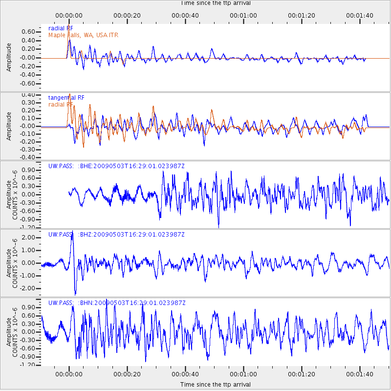
PASS Maple Falls, WA, USA - Earthquake Result Viewer
*The percent match for this event was below the threshold and hence no stack was calculated.
| Earthquake location: |
Guatemala |
| Earthquake latitude/longitude: |
14.6/-91.2 |
| Earthquake time(UTC): |
2009/05/03 (123) 16:21:47 GMT |
| Earthquake Depth: |
124 km |
| Earthquake Magnitude: |
5.6 MB, 6.2 MW, 6.2 MW |
| Earthquake Catalog/Contributor: |
WHDF/NEIC |
|
| Network: |
UW Pacific Northwest Regional Seismic Network |
| Station: |
PASS Maple Falls, WA, USA |
| Lat/Lon: |
49.00 N/122.09 W |
| Elevation: |
174 m |
|
| Distance: |
42.7 deg |
| Az: |
330.054 deg |
| Baz: |
132.786 deg |
| Ray Param: |
$rayparam |
*The percent match for this event was below the threshold and hence was not used in the summary stack. |
|
| Radial Match: |
71.70866 % |
| Radial Bump: |
400 |
| Transverse Match: |
64.910904 % |
| Transverse Bump: |
400 |
| SOD ConfigId: |
2658 |
| Insert Time: |
2010-02-27 05:00:06.193 +0000 |
| GWidth: |
2.5 |
| Max Bumps: |
400 |
| Tol: |
0.001 |
|
Signal To Noise
| Channel | StoN | STA | LTA |
| UW:PASS: :BHZ:20090503T16:29:01.023987Z | 7.621969 | 1.216497E-6 | 1.5960403E-7 |
| UW:PASS: :BHN:20090503T16:29:01.023987Z | 2.0732477 | 5.27614E-7 | 2.5448674E-7 |
| UW:PASS: :BHE:20090503T16:29:01.023987Z | 2.2815151 | 4.1469275E-7 | 1.81762E-7 |
| Arrivals |
| Ps | |
| PpPs | |
| PsPs/PpSs | |


