You are here: Home > Network List > GS - US Geological Survey Networks Stations List
> Station ETX08 Co Rd 4789, Timpson, TX, USA > Earthquake Result Viewer
ETX08 Co Rd 4789, Timpson, TX, USA - Earthquake Result Viewer
| Earthquake location: |
Northern Chile |
| Earthquake latitude/longitude: |
-19.3/-69.2 |
| Earthquake time(UTC): |
2013/07/10 (191) 14:32:12 GMT |
| Earthquake Depth: |
110 km |
| Earthquake Magnitude: |
5.7 MW, 5.6 MW, 5.7 MB |
| Earthquake Catalog/Contributor: |
NEIC PDE/NEIC PDE-W |
|
| Network: |
GS US Geological Survey Networks |
| Station: |
ETX08 Co Rd 4789, Timpson, TX, USA |
| Lat/Lon: |
31.84 N/94.42 W |
| Elevation: |
107 m |
|
| Distance: |
56.3 deg |
| Az: |
334.202 deg |
| Baz: |
151.124 deg |
| Ray Param: |
0.06390635 |
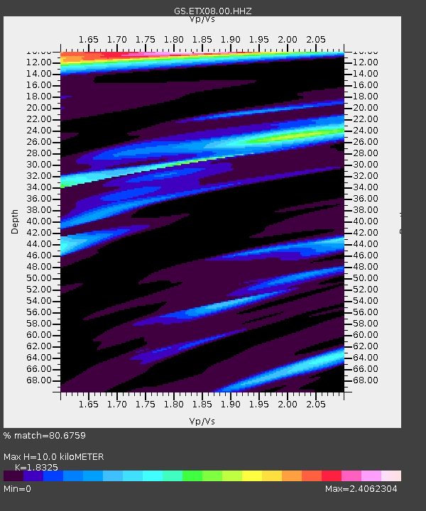
| Estimated Moho Depth: |
10.0 km |
| Estimated Crust Vp/Vs: |
1.83 |
| Assumed Crust Vp: |
5.738 km/s |
| Estimated Crust Vs: |
3.131 km/s |
| Estimated Crust Poisson's Ratio: |
0.29 |
|
| Radial Match: |
80.6759 % |
| Radial Bump: |
400 |
| Transverse Match: |
61.75002 % |
| Transverse Bump: |
400 |
| SOD ConfigId: |
512894 |
| Insert Time: |
2013-09-15 17:43:36.507 +0000 |
| GWidth: |
2.5 |
| Max Bumps: |
400 |
| Tol: |
0.001 |
|

Signal To Noise
| Channel | StoN | STA | LTA |
| GS:ETX08:00:HHZ:20130710T14:41:11.399023Z | 11.050195 | 6.89299E-7 | 6.23789E-8 |
| GS:ETX08:00:HH1:20130710T14:41:11.399023Z | 2.136148 | 1.8218464E-7 | 8.528653E-8 |
| GS:ETX08:00:HH2:20130710T14:41:11.399023Z | 1.144448 | 1.0354372E-7 | 9.0474806E-8 |
| Arrivals |
| Ps | 1.5 SECOND |
| PpPs | 4.7 SECOND |
| PsPs/PpSs | 6.3 SECOND |


