You are here: Home > Network List > IW - Intermountain West Stations List
> Station MOOW Moose Ponds, Wyoming, USA > Earthquake Result Viewer
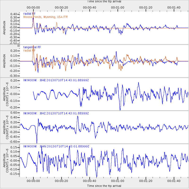
MOOW Moose Ponds, Wyoming, USA - Earthquake Result Viewer
*The percent match for this event was below the threshold and hence no stack was calculated.
| Earthquake location: |
Northern Chile |
| Earthquake latitude/longitude: |
-19.3/-69.2 |
| Earthquake time(UTC): |
2013/07/10 (191) 14:32:12 GMT |
| Earthquake Depth: |
110 km |
| Earthquake Magnitude: |
5.7 MW, 5.6 MW, 5.7 MB |
| Earthquake Catalog/Contributor: |
NEIC PDE/NEIC PDE-W |
|
| Network: |
IW Intermountain West |
| Station: |
MOOW Moose Ponds, Wyoming, USA |
| Lat/Lon: |
43.75 N/110.74 W |
| Elevation: |
2128 m |
|
| Distance: |
73.4 deg |
| Az: |
329.925 deg |
| Baz: |
139.223 deg |
| Ray Param: |
$rayparam |
*The percent match for this event was below the threshold and hence was not used in the summary stack. |
|
| Radial Match: |
71.00832 % |
| Radial Bump: |
400 |
| Transverse Match: |
66.85701 % |
| Transverse Bump: |
400 |
| SOD ConfigId: |
512894 |
| Insert Time: |
2013-09-15 17:46:01.682 +0000 |
| GWidth: |
2.5 |
| Max Bumps: |
400 |
| Tol: |
0.001 |
|
Signal To Noise
| Channel | StoN | STA | LTA |
| IW:MOOW: :BHZ:20130710T14:43:01.88999Z | 3.759139 | 2.24543E-7 | 5.9732564E-8 |
| IW:MOOW: :BHN:20130710T14:43:01.88999Z | 1.6211481 | 5.6572098E-8 | 3.4896317E-8 |
| IW:MOOW: :BHE:20130710T14:43:01.88999Z | 1.8555436 | 7.376214E-8 | 3.9752308E-8 |
| Arrivals |
| Ps | |
| PpPs | |
| PsPs/PpSs | |


