You are here: Home > Network List > TA - USArray Transportable Network (new EarthScope stations) Stations List
> Station F39A Loretta, WI, USA > Earthquake Result Viewer
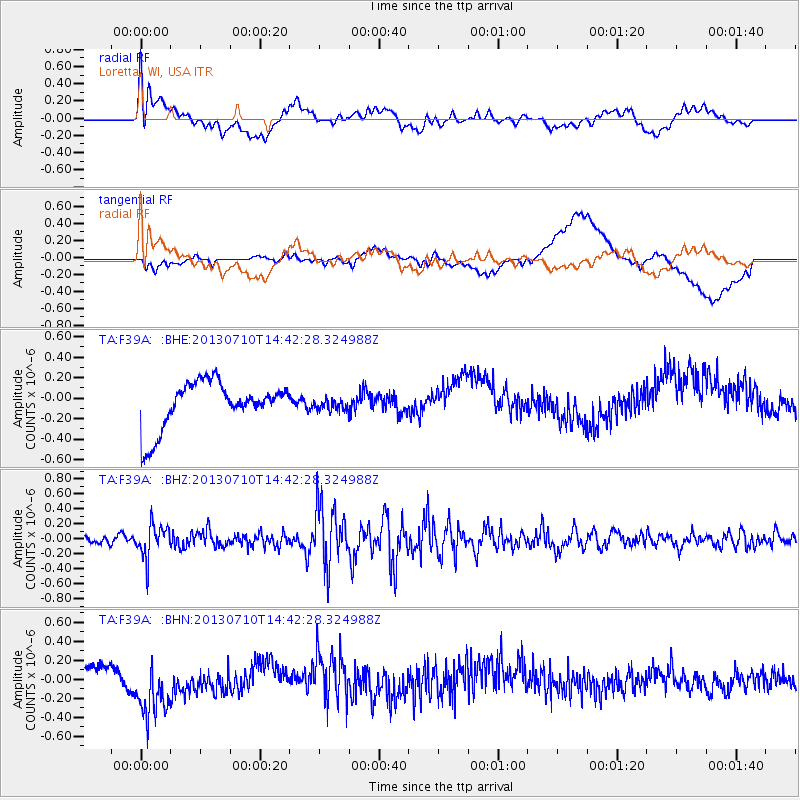
F39A Loretta, WI, USA - Earthquake Result Viewer
*The percent match for this event was below the threshold and hence no stack was calculated.
| Earthquake location: |
Northern Chile |
| Earthquake latitude/longitude: |
-19.3/-69.2 |
| Earthquake time(UTC): |
2013/07/10 (191) 14:32:12 GMT |
| Earthquake Depth: |
110 km |
| Earthquake Magnitude: |
5.7 MW, 5.6 MW, 5.7 MB |
| Earthquake Catalog/Contributor: |
NEIC PDE/NEIC PDE-W |
|
| Network: |
TA USArray Transportable Network (new EarthScope stations) |
| Station: |
F39A Loretta, WI, USA |
| Lat/Lon: |
45.92 N/90.92 W |
| Elevation: |
440 m |
|
| Distance: |
67.8 deg |
| Az: |
343.835 deg |
| Baz: |
157.874 deg |
| Ray Param: |
$rayparam |
*The percent match for this event was below the threshold and hence was not used in the summary stack. |
|
| Radial Match: |
46.462753 % |
| Radial Bump: |
400 |
| Transverse Match: |
21.385382 % |
| Transverse Bump: |
400 |
| SOD ConfigId: |
512894 |
| Insert Time: |
2013-09-15 17:57:57.382 +0000 |
| GWidth: |
2.5 |
| Max Bumps: |
400 |
| Tol: |
0.001 |
|
Signal To Noise
| Channel | StoN | STA | LTA |
| TA:F39A: :BHZ:20130710T14:42:28.324988Z | 4.6959887 | 2.2182844E-7 | 4.7237855E-8 |
| TA:F39A: :BHN:20130710T14:42:28.324988Z | 2.5114386 | 3.1068177E-7 | 1.237067E-7 |
| TA:F39A: :BHE:20130710T14:42:28.324988Z | 0.25316414 | 5.709711E-8 | 2.2553395E-7 |
| Arrivals |
| Ps | |
| PpPs | |
| PsPs/PpSs | |


