You are here: Home > Network List > TA - USArray Transportable Network (new EarthScope stations) Stations List
> Station L48A N Adams, MI, USA > Earthquake Result Viewer
L48A N Adams, MI, USA - Earthquake Result Viewer
| Earthquake location: |
Northern Chile |
| Earthquake latitude/longitude: |
-19.3/-69.2 |
| Earthquake time(UTC): |
2013/07/10 (191) 14:32:12 GMT |
| Earthquake Depth: |
110 km |
| Earthquake Magnitude: |
5.7 MW, 5.6 MW, 5.7 MB |
| Earthquake Catalog/Contributor: |
NEIC PDE/NEIC PDE-W |
|
| Network: |
TA USArray Transportable Network (new EarthScope stations) |
| Station: |
L48A N Adams, MI, USA |
| Lat/Lon: |
41.94 N/84.43 W |
| Elevation: |
369 m |
|
| Distance: |
62.5 deg |
| Az: |
347.277 deg |
| Baz: |
163.81 deg |
| Ray Param: |
0.059856303 |
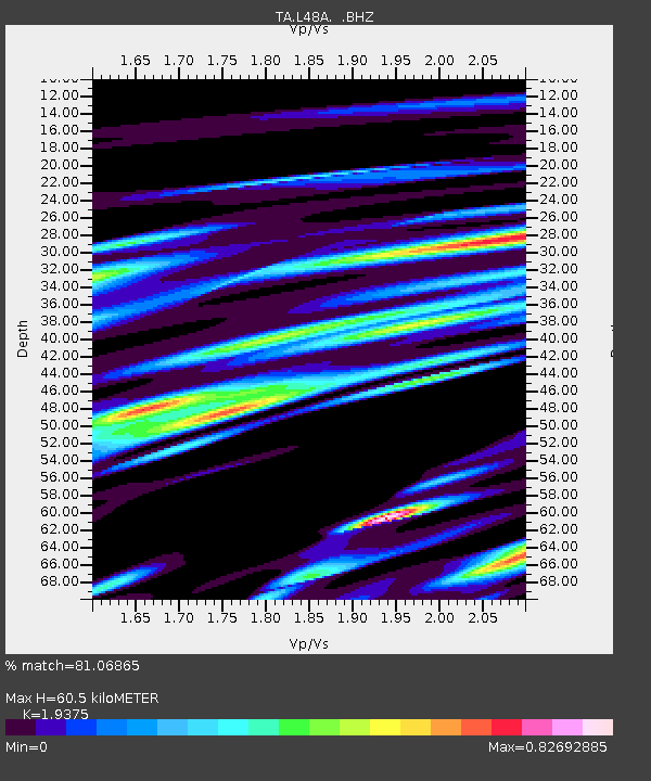
| Estimated Moho Depth: |
60.5 km |
| Estimated Crust Vp/Vs: |
1.94 |
| Assumed Crust Vp: |
6.498 km/s |
| Estimated Crust Vs: |
3.354 km/s |
| Estimated Crust Poisson's Ratio: |
0.32 |
|
| Radial Match: |
81.06865 % |
| Radial Bump: |
400 |
| Transverse Match: |
62.875103 % |
| Transverse Bump: |
400 |
| SOD ConfigId: |
512894 |
| Insert Time: |
2013-09-15 18:01:05.905 +0000 |
| GWidth: |
2.5 |
| Max Bumps: |
400 |
| Tol: |
0.001 |
|
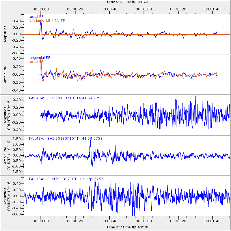
Signal To Noise
| Channel | StoN | STA | LTA |
| TA:L48A: :BHZ:20130710T14:41:54.275Z | 4.9629583 | 2.7715802E-7 | 5.5845323E-8 |
| TA:L48A: :BHN:20130710T14:41:54.275Z | 1.9479245 | 1.2426044E-7 | 6.3791205E-8 |
| TA:L48A: :BHE:20130710T14:41:54.275Z | 1.0229309 | 6.635982E-8 | 6.487224E-8 |
| Arrivals |
| Ps | 9.1 SECOND |
| PpPs | 26 SECOND |
| PsPs/PpSs | 35 SECOND |


