You are here: Home > Network List > TA - USArray Transportable Network (new EarthScope stations) Stations List
> Station L44A Lake County Forest Preserve, Grayslake, IL, USA > Earthquake Result Viewer
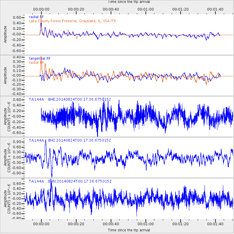
L44A Lake County Forest Preserve, Grayslake, IL, USA - Earthquake Result Viewer
*The percent match for this event was below the threshold and hence no stack was calculated.
| Earthquake location: |
Iceland |
| Earthquake latitude/longitude: |
64.7/-17.4 |
| Earthquake time(UTC): |
2014/08/24 (236) 00:09:53 GMT |
| Earthquake Depth: |
6.2 km |
| Earthquake Magnitude: |
5.3 MW, 5.3 mb |
| Earthquake Catalog/Contributor: |
ISC/ISC |
|
| Network: |
TA USArray Transportable Network (new EarthScope stations) |
| Station: |
L44A Lake County Forest Preserve, Grayslake, IL, USA |
| Lat/Lon: |
42.18 N/87.91 W |
| Elevation: |
202 m |
|
| Distance: |
44.7 deg |
| Az: |
275.172 deg |
| Baz: |
35.198 deg |
| Ray Param: |
$rayparam |
*The percent match for this event was below the threshold and hence was not used in the summary stack. |
|
| Radial Match: |
69.03642 % |
| Radial Bump: |
400 |
| Transverse Match: |
63.239555 % |
| Transverse Bump: |
400 |
| SOD ConfigId: |
3390531 |
| Insert Time: |
2019-04-13 13:58:24.812 +0000 |
| GWidth: |
2.5 |
| Max Bumps: |
400 |
| Tol: |
0.001 |
|
Signal To Noise
| Channel | StoN | STA | LTA |
| TA:L44A: :BHZ:20140824T00:17:36.675015Z | 2.5606933 | 4.3289162E-7 | 1.6905251E-7 |
| TA:L44A: :BHN:20140824T00:17:36.675015Z | 1.3224989 | 2.2392102E-7 | 1.6931659E-7 |
| TA:L44A: :BHE:20140824T00:17:36.675015Z | 1.3606604 | 2.5421886E-7 | 1.8683491E-7 |
| Arrivals |
| Ps | |
| PpPs | |
| PsPs/PpSs | |


