You are here: Home > Network List > TA - USArray Transportable Network (new EarthScope stations) Stations List
> Station M47A Cromwell, IN, USA > Earthquake Result Viewer
M47A Cromwell, IN, USA - Earthquake Result Viewer
| Earthquake location: |
Northern Chile |
| Earthquake latitude/longitude: |
-19.3/-69.2 |
| Earthquake time(UTC): |
2013/07/10 (191) 14:32:12 GMT |
| Earthquake Depth: |
110 km |
| Earthquake Magnitude: |
5.7 MW, 5.6 MW, 5.7 MB |
| Earthquake Catalog/Contributor: |
NEIC PDE/NEIC PDE-W |
|
| Network: |
TA USArray Transportable Network (new EarthScope stations) |
| Station: |
M47A Cromwell, IN, USA |
| Lat/Lon: |
41.36 N/85.62 W |
| Elevation: |
283 m |
|
| Distance: |
62.2 deg |
| Az: |
346.124 deg |
| Baz: |
162.489 deg |
| Ray Param: |
0.060049724 |
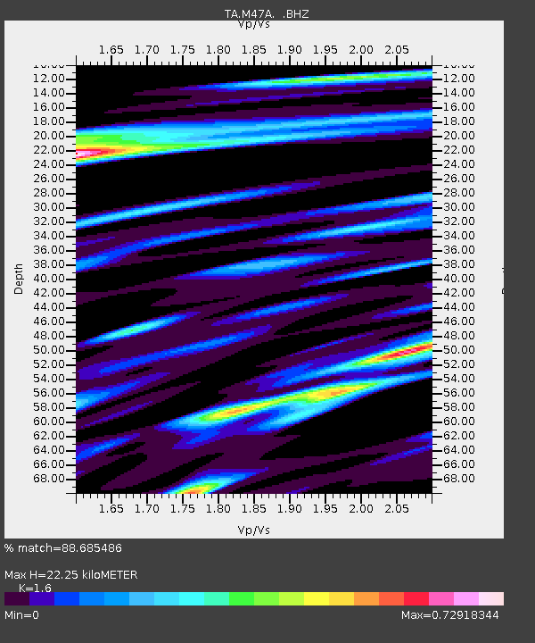
| Estimated Moho Depth: |
22.25 km |
| Estimated Crust Vp/Vs: |
1.60 |
| Assumed Crust Vp: |
6.498 km/s |
| Estimated Crust Vs: |
4.061 km/s |
| Estimated Crust Poisson's Ratio: |
0.18 |
|
| Radial Match: |
88.685486 % |
| Radial Bump: |
400 |
| Transverse Match: |
65.543915 % |
| Transverse Bump: |
400 |
| SOD ConfigId: |
512894 |
| Insert Time: |
2013-09-15 18:01:48.203 +0000 |
| GWidth: |
2.5 |
| Max Bumps: |
400 |
| Tol: |
0.001 |
|
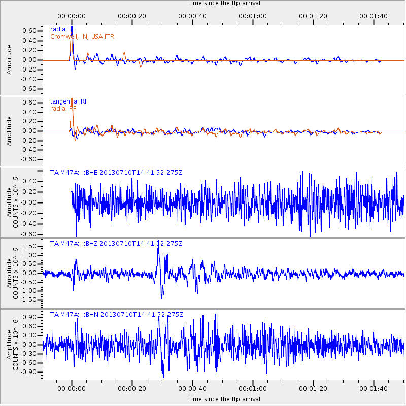
Signal To Noise
| Channel | StoN | STA | LTA |
| TA:M47A: :BHZ:20130710T14:41:52.275Z | 3.94681 | 3.450805E-7 | 8.743276E-8 |
| TA:M47A: :BHN:20130710T14:41:52.275Z | 1.5016574 | 2.9156794E-7 | 1.941641E-7 |
| TA:M47A: :BHE:20130710T14:41:52.275Z | 0.7316981 | 1.2395138E-7 | 1.6940236E-7 |
| Arrivals |
| Ps | 2.2 SECOND |
| PpPs | 8.5 SECOND |
| PsPs/PpSs | 11 SECOND |


