You are here: Home > Network List > TA - USArray Transportable Network (new EarthScope stations) Stations List
> Station M48A Edgerton, OH, USA > Earthquake Result Viewer
M48A Edgerton, OH, USA - Earthquake Result Viewer

| Earthquake location: |
Northern Chile |
| Earthquake latitude/longitude: |
-19.3/-69.2 |
| Earthquake time(UTC): |
2013/07/10 (191) 14:32:12 GMT |
| Earthquake Depth: |
110 km |
| Earthquake Magnitude: |
5.7 MW, 5.6 MW, 5.7 MB |
| Earthquake Catalog/Contributor: |
NEIC PDE/NEIC PDE-W |
|
| Network: |
TA USArray Transportable Network (new EarthScope stations) |
| Station: |
M48A Edgerton, OH, USA |
| Lat/Lon: |
41.48 N/84.72 W |
| Elevation: |
258 m |
|
| Distance: |
62.2 deg |
| Az: |
346.901 deg |
| Baz: |
163.447 deg |
| Ray Param: |
0.06010093 |
| Estimated Moho Depth: |
40.25 km |
| Estimated Crust Vp/Vs: |
1.77 |
| Assumed Crust Vp: |
6.498 km/s |
| Estimated Crust Vs: |
3.671 km/s |
| Estimated Crust Poisson's Ratio: |
0.27 |
|
| Radial Match: |
80.12142 % |
| Radial Bump: |
400 |
| Transverse Match: |
52.296726 % |
| Transverse Bump: |
400 |
| SOD ConfigId: |
512894 |
| Insert Time: |
2013-09-15 18:01:50.452 +0000 |
| GWidth: |
2.5 |
| Max Bumps: |
400 |
| Tol: |
0.001 |
|
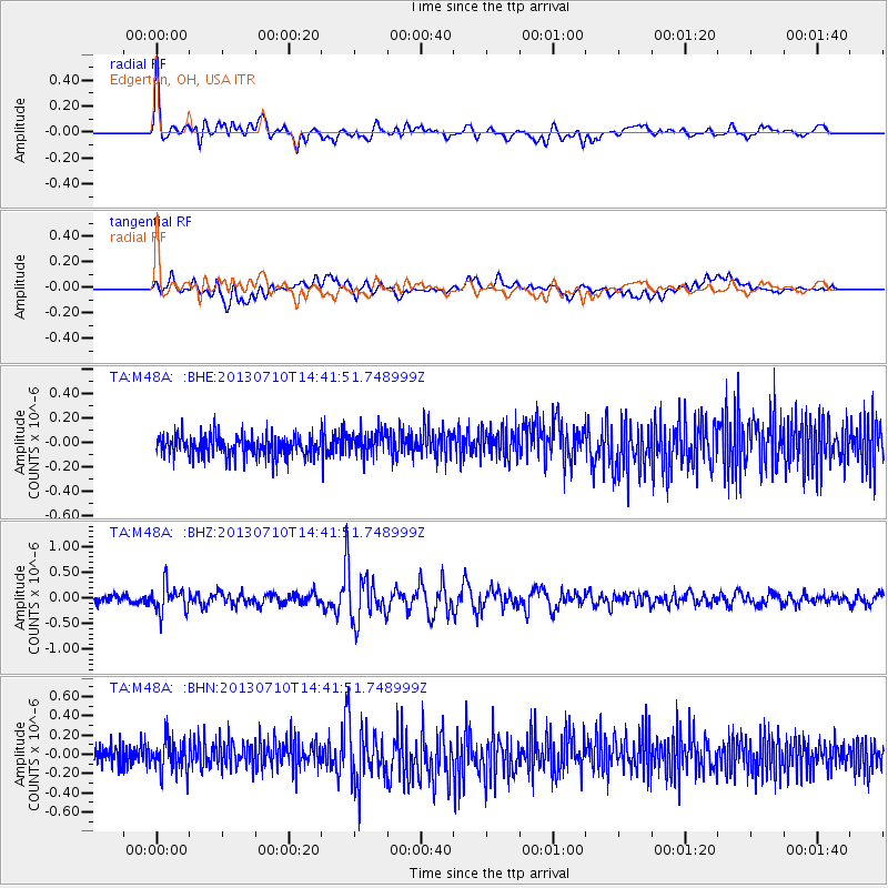
Signal To Noise
| Channel | StoN | STA | LTA |
| TA:M48A: :BHZ:20130710T14:41:51.748999Z | 3.2378569 | 2.5859987E-7 | 7.9867604E-8 |
| TA:M48A: :BHN:20130710T14:41:51.748999Z | 1.675727 | 1.623359E-7 | 9.6874906E-8 |
| TA:M48A: :BHE:20130710T14:41:51.748999Z | 1.1583298 | 1.0014146E-7 | 8.645332E-8 |
| Arrivals |
| Ps | 5.0 SECOND |
| PpPs | 16 SECOND |
| PsPs/PpSs | 21 SECOND |


