You are here: Home > Network List > TA - USArray Transportable Network (new EarthScope stations) Stations List
> Station N51A Ashland, OH, USA > Earthquake Result Viewer
N51A Ashland, OH, USA - Earthquake Result Viewer
| Earthquake location: |
Iceland |
| Earthquake latitude/longitude: |
64.7/-17.4 |
| Earthquake time(UTC): |
2014/08/24 (236) 00:09:53 GMT |
| Earthquake Depth: |
6.2 km |
| Earthquake Magnitude: |
5.3 MW, 5.3 mb |
| Earthquake Catalog/Contributor: |
ISC/ISC |
|
| Network: |
TA USArray Transportable Network (new EarthScope stations) |
| Station: |
N51A Ashland, OH, USA |
| Lat/Lon: |
40.92 N/82.37 W |
| Elevation: |
343 m |
|
| Distance: |
43.4 deg |
| Az: |
269.231 deg |
| Baz: |
34.585 deg |
| Ray Param: |
0.072618425 |
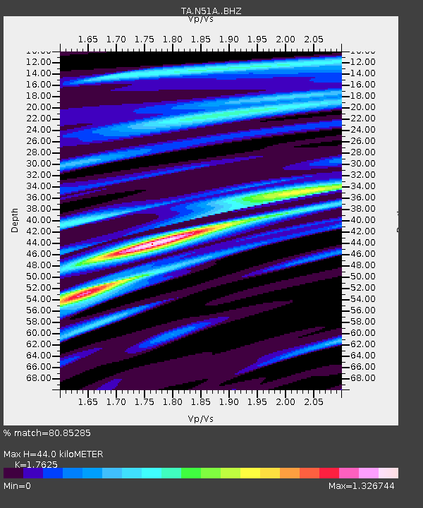
| Estimated Moho Depth: |
44.0 km |
| Estimated Crust Vp/Vs: |
1.76 |
| Assumed Crust Vp: |
6.498 km/s |
| Estimated Crust Vs: |
3.687 km/s |
| Estimated Crust Poisson's Ratio: |
0.26 |
|
| Radial Match: |
80.85285 % |
| Radial Bump: |
400 |
| Transverse Match: |
72.704926 % |
| Transverse Bump: |
400 |
| SOD ConfigId: |
3390531 |
| Insert Time: |
2019-04-13 13:58:38.196 +0000 |
| GWidth: |
2.5 |
| Max Bumps: |
400 |
| Tol: |
0.001 |
|

Signal To Noise
| Channel | StoN | STA | LTA |
| TA:N51A: :BHZ:20140824T00:17:25.874996Z | 3.4075985 | 5.221401E-7 | 1.5322819E-7 |
| TA:N51A: :BHN:20140824T00:17:25.874996Z | 2.329341 | 2.3941996E-7 | 1.02784426E-7 |
| TA:N51A: :BHE:20140824T00:17:25.874996Z | 2.053775 | 2.5762526E-7 | 1.2543985E-7 |
| Arrivals |
| Ps | 5.5 SECOND |
| PpPs | 17 SECOND |
| PsPs/PpSs | 23 SECOND |


