You are here: Home > Network List > TA - USArray Transportable Network (new EarthScope stations) Stations List
> Station N46A Monticello, IN, USA > Earthquake Result Viewer
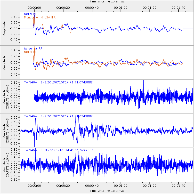
N46A Monticello, IN, USA - Earthquake Result Viewer
*The percent match for this event was below the threshold and hence no stack was calculated.
| Earthquake location: |
Northern Chile |
| Earthquake latitude/longitude: |
-19.3/-69.2 |
| Earthquake time(UTC): |
2013/07/10 (191) 14:32:12 GMT |
| Earthquake Depth: |
110 km |
| Earthquake Magnitude: |
5.7 MW, 5.6 MW, 5.7 MB |
| Earthquake Catalog/Contributor: |
NEIC PDE/NEIC PDE-W |
|
| Network: |
TA USArray Transportable Network (new EarthScope stations) |
| Station: |
N46A Monticello, IN, USA |
| Lat/Lon: |
40.89 N/86.74 W |
| Elevation: |
209 m |
|
| Distance: |
62.1 deg |
| Az: |
345.057 deg |
| Baz: |
161.26 deg |
| Ray Param: |
$rayparam |
*The percent match for this event was below the threshold and hence was not used in the summary stack. |
|
| Radial Match: |
75.92272 % |
| Radial Bump: |
400 |
| Transverse Match: |
59.88138 % |
| Transverse Bump: |
400 |
| SOD ConfigId: |
512894 |
| Insert Time: |
2013-09-15 18:02:48.267 +0000 |
| GWidth: |
2.5 |
| Max Bumps: |
400 |
| Tol: |
0.001 |
|
Signal To Noise
| Channel | StoN | STA | LTA |
| TA:N46A: :BHZ:20130710T14:41:51.074988Z | 6.5716195 | 3.49329E-7 | 5.315722E-8 |
| TA:N46A: :BHN:20130710T14:41:51.074988Z | 1.897578 | 2.3773607E-7 | 1.2528396E-7 |
| TA:N46A: :BHE:20130710T14:41:51.074988Z | 1.1772399 | 1.6764083E-7 | 1.4240159E-7 |
| Arrivals |
| Ps | |
| PpPs | |
| PsPs/PpSs | |


