You are here: Home > Network List > TA - USArray Transportable Network (new EarthScope stations) Stations List
> Station Q53A Leroy, WV, USA > Earthquake Result Viewer
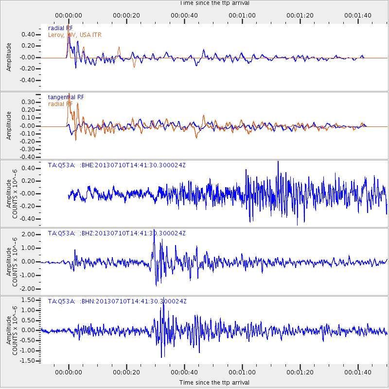
Q53A Leroy, WV, USA - Earthquake Result Viewer
*The percent match for this event was below the threshold and hence no stack was calculated.
| Earthquake location: |
Northern Chile |
| Earthquake latitude/longitude: |
-19.3/-69.2 |
| Earthquake time(UTC): |
2013/07/10 (191) 14:32:12 GMT |
| Earthquake Depth: |
110 km |
| Earthquake Magnitude: |
5.7 MW, 5.6 MW, 5.7 MB |
| Earthquake Catalog/Contributor: |
NEIC PDE/NEIC PDE-W |
|
| Network: |
TA USArray Transportable Network (new EarthScope stations) |
| Station: |
Q53A Leroy, WV, USA |
| Lat/Lon: |
38.86 N/81.53 W |
| Elevation: |
310 m |
|
| Distance: |
59.0 deg |
| Az: |
348.831 deg |
| Baz: |
166.448 deg |
| Ray Param: |
$rayparam |
*The percent match for this event was below the threshold and hence was not used in the summary stack. |
|
| Radial Match: |
78.506226 % |
| Radial Bump: |
400 |
| Transverse Match: |
72.01451 % |
| Transverse Bump: |
400 |
| SOD ConfigId: |
512894 |
| Insert Time: |
2013-09-15 18:05:29.053 +0000 |
| GWidth: |
2.5 |
| Max Bumps: |
400 |
| Tol: |
0.001 |
|
Signal To Noise
| Channel | StoN | STA | LTA |
| TA:Q53A: :BHZ:20130710T14:41:30.300024Z | 5.884027 | 2.9130936E-7 | 4.95085E-8 |
| TA:Q53A: :BHN:20130710T14:41:30.300024Z | 2.6435938 | 1.4198032E-7 | 5.370731E-8 |
| TA:Q53A: :BHE:20130710T14:41:30.300024Z | 1.3703595 | 7.107056E-8 | 5.186271E-8 |
| Arrivals |
| Ps | |
| PpPs | |
| PsPs/PpSs | |


